Mākhjan geodata
Mākhjan (Maharashtra) is a populated place; located in India in Asia/Kolkata (GMT+5.5) time zone. With population of 10,000 people, there are 2941 cities with bigger population in this country. Compared to other cities in India, 74.1% of cities are located further ↑North; 92.5% of cities are located further →East and 87.6% of cities have higher elevation than Mākhjan. Note1


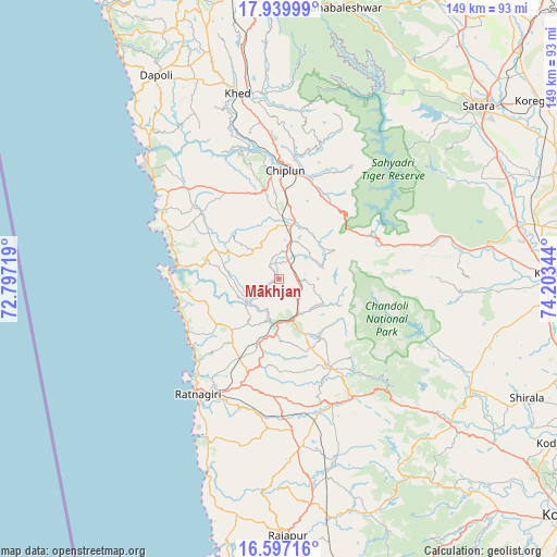
Mākhjan GPS coordinates[2]
17° 16' 11.28" North, 73° 30' 1.116" East
| Map corner | latitude | longitude |
|---|---|---|
| Upper-left | 17.93999°, | 72.79719° |
| Center: | 17.2698°, | 73.50031° |
| Lower-right: | 16.59716°, | 74.20344° |
| Map W x H: | 149.3×149.3 km | = 92.8×92.8mi |
| max Lat: | 34.9274° ⇑74.1% North |
| Mākhjan: | 17.2698° |
| min Lat: | ⇓25.9% South 8.09008° |
| min Long | Mākhjan | max Long |
| 68.82655° | 73.50031° | 96.81° |
| W 7.5%⇐ | ⇒92.5% E |
Elevation
Elevation of Mākhjan is 23 m = 75 ft, and this is 272.6 m = 894 ft below average elevation for this country.
| Max E: |
3681 m = 12077 ft | 87.6% |
| Avg. | 295.6 m = 970 ft | |
| Mākhjan | 23 m = 75 ft | |
Min E: |
1 m = 3 ft | 12.4% |
See also: India elevation on elevation.city.
Geographical zone
Mākhjan is located in North Torrid zone (between Equator and Tropic of Cancer). Distance of this Northern Tropic circle is 685.7 km =426.1 mi to North.| Distance of | km | miles | from Mākhjan |
|---|---|---|---|
| North Pole | 8086.8 | 5024.9 | to North |
| Arctic Circle | 5481 | 3405.7 | to North |
| Tropic Cancer | 685.7 | 426.1 | to North |
| Equator | 1920.2 | 1193.2 | to South |


Nearby cities:
15 places around Mākhjan: (largest is in red/bold)
• Chiplūn
29.3 km =18.2 mi,  1°
1°
• Dābhol
49.2 km =30.6 mi,  316°
316°
• Guhāgar
40.4 km =25.1 mi,  306°
306°
• Jalgaon
61.7 km =38.3 mi,  327°
327°
• Karād
72.4 km =45 mi,  88°
88°
• Khed
51.1 km =31.8 mi,  347°
347°
• Koynanagar
31.8 km =19.8 mi,  62°
62°
• Lānja
45.8 km =28.5 mi,  173°
173°
• Mahābaleshwar
34 km =21.1 mi,  341°
341°
• Malkapur
71.7 km =44.6 mi, 90°
• Malkāpur
60.4 km =37.5 mi,  130°
130°
• Pātan
44.2 km =27.5 mi,  74°
74°
• Ratnagiri
36.9 km =22.9 mi,  213°
213°
• Rājāpur
68.2 km =42.4 mi,  178°
178°
• Satara
69.8 km =43.4 mi,  48°
48°
Sources, notices
• [Note1] Compared only with cities in India existing in our database
• [Src1] Map data: © OpenStreetMap contributors (CC-BY-SA)
• [Src2] Other city data from geonames.org with taken over terms of usage.
• [Src3] Geographical zone / Annual Mean Temperature by Robert A. Rohde @ Wikipedia
