Bhātāpāra geodata
Bhātāpāra (Chhattisgarh) is a populated place; located in India in Asia/Kolkata (GMT+5.5) time zone. With population of 51,751 people, there are 862 cities with bigger population in this country. Compared to other cities in India, 57.8% of cities are located further ↑North; 76.4% of cities are located further ←West and 63.4% of cities have lower elevation than Bhātāpāra. Note1


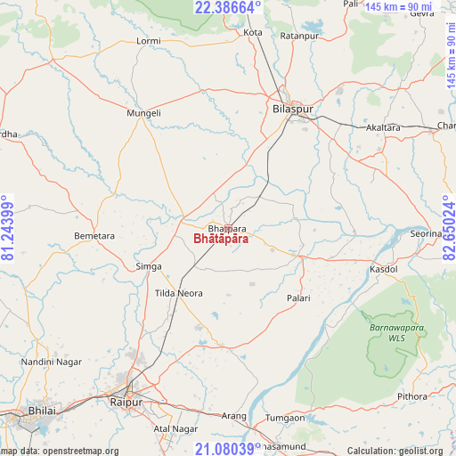
Bhātāpāra GPS coordinates[2]
21° 44' 6" North, 81° 56' 49.596" East
| Map corner | latitude | longitude |
|---|---|---|
| Upper-left | 22.38664°, | 81.24399° |
| Center: | 21.735°, | 81.94711° |
| Lower-right: | 21.08039°, | 82.65024° |
| Map W x H: | 145.2×145.2 km | = 90.2×90.2mi |
| max Lat: | 34.9274° ⇑57.8% North |
| Bhātāpāra: | 21.735° |
| min Lat: | ⇓42.2% South 8.09008° |
| min Long | Bhātāpāra | max Long |
| 68.82655° | 81.94711° | 96.81° |
| W 76.4%⇐ | ⇒23.6% E |
Elevation
Elevation of Bhātāpāra is 275 m = 902 ft, and this is 20.6 m = 68 ft below average elevation for this country.
| Max E: |
3681 m = 12077 ft | 36.6% |
| Avg. | 295.6 m = 970 ft | |
| Bhātāpāra | 275 m = 902 ft | |
Min E: |
1 m = 3 ft | 63.4% |
See also: Bhātāpāra elevation on elevation.city.
Geographical zone
Bhātāpāra is located in North Torrid zone (between Equator and Tropic of Cancer). Distance of this Northern Tropic circle is 189.2 km =117.6 mi to North.| Distance of | km | miles | from Bhātāpāra |
|---|---|---|---|
| North Pole | 7590.4 | 4716.5 | to North |
| Arctic Circle | 4984.5 | 3097.2 | to North |
| Tropic Cancer | 189.2 | 117.6 | to North |
| Equator | 2416.7 | 1501.7 | to South |


Nearby cities:
15 places around Bhātāpāra: (largest is in red/bold)
• Akaltara
59 km =36.7 mi,  56°
56°
• Arang
59.9 km =37.2 mi,  177°
177°
• Baloda Bāzār
23.7 km =14.7 mi,  111°
111°
• Bemetāra
42.7 km =26.5 mi,  267°
267°
• Bilāspur
44 km =27.3 mi,  29°
29°
• Kharod
65.2 km =40.5 mi,  89°
89°
• Kotā
62.8 km =39 mi,  7°
7°
• Kumhāri
68.5 km =42.6 mi,  220°
220°
• Lormi
65.1 km =40.5 mi,  337°
337°
• Mungeli
45.6 km =28.3 mi,  323°
323°
• Raipur
64.5 km =40.1 mi,  210°
210°
• Ratanpur
65.4 km =40.6 mi,  20°
20°
• Seorīnārāyan
66.8 km =41.5 mi, 91°
• Simga
27.8 km =17.3 mi,  244°
244°
• Takhatpur
44.5 km =27.7 mi,  349°
349°
Sources, notices
• [Note1] Compared only with cities in India existing in our database
• [Src1] Map data: © OpenStreetMap contributors (CC-BY-SA)
• [Src2] Other city data from geonames.org with taken over terms of usage.
• [Src3] Geographical zone / Annual Mean Temperature by Robert A. Rohde @ Wikipedia
