Arang geodata
Arang (Chhattisgarh) is a populated place; located in India in Asia/Kolkata (GMT+5.5) time zone. With population of 17,503 people, there are 2237 cities with bigger population in this country. Compared to other cities in India, 60.7% of cities are located further ↑North; 76.5% of cities are located further ←West and 64.8% of cities have lower elevation than Arang. Note1


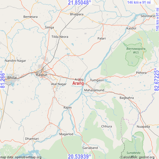
Arang GPS coordinates[2]
21° 11' 47.004" North, 81° 58' 8.832" East
| Map corner | latitude | longitude |
|---|---|---|
| Upper-left | 21.85048°, | 81.266° |
| Center: | 21.19639°, | 81.96912° |
| Lower-right: | 20.53939°, | 82.67225° |
| Map W x H: | 145.8×145.8 km | = 90.6×90.6mi |
| max Lat: | 34.9274° ⇑60.7% North |
| Arang: | 21.19639° |
| min Lat: | ⇓39.3% South 8.09008° |
| min Long | Arang | max Long |
| 68.82655° | 81.96912° | 96.81° |
| W 76.5%⇐ | ⇒23.5% E |
Elevation
Elevation of Arang is 284 m = 932 ft, and this is 11.6 m = 38 ft below average elevation for this country.
| Max E: |
3681 m = 12077 ft | 35.2% |
| Avg. | 295.6 m = 970 ft | |
| Arang | 284 m = 932 ft | |
Min E: |
1 m = 3 ft | 64.8% |
See also: India elevation on elevation.city.
Geographical zone
Arang is located in North Torrid zone (between Equator and Tropic of Cancer). Distance of this Northern Tropic circle is 249.1 km =154.8 mi to North.| Distance of | km | miles | from Arang |
|---|---|---|---|
| North Pole | 7650.2 | 4753.6 | to North |
| Arctic Circle | 5044.4 | 3134.4 | to North |
| Tropic Cancer | 249.1 | 154.8 | to North |
| Equator | 2356.8 | 1464.4 | to South |


Nearby cities:
15 places around Arang: (largest is in red/bold)
• Baloda Bāzār
54.9 km =34.1 mi,  21°
21°
• Bhatgaon
28.4 km =17.6 mi,  259°
259°
• Bhilai
56.1 km =34.9 mi,  271°
271°
• Bhātāpāra
59.9 km =37.2 mi,  357°
357°
• Dhamtari
69.7 km =43.3 mi,  218°
218°
• Durg
71.8 km =44.6 mi, 269°
• Gariāband
63.4 km =39.4 mi,  171°
171°
• Khamharia
38.2 km =23.7 mi,  129°
129°
• Kumhāri
47.5 km =29.5 mi,  279°
279°
• Kurud
48.1 km =29.9 mi,  212°
212°
• Mahāsamund
16.4 km =10.2 mi, 127°
• Pithora
57.1 km =35.5 mi,  83°
83°
• Pātan
48.7 km =30.3 mi,  248°
248°
• Raipur
35 km =21.7 mi, 276°
• Simga
55.3 km =34.4 mi,  330°
330°
Sources, notices
• [Note1] Compared only with cities in India existing in our database
• [Src1] Map data: © OpenStreetMap contributors (CC-BY-SA)
• [Src2] Other city data from geonames.org with taken over terms of usage.
• [Src3] Geographical zone / Annual Mean Temperature by Robert A. Rohde @ Wikipedia
