Mahāsamund geodata
Mahāsamund (Chhattisgarh) is a populated place; located in India in Asia/Kolkata (GMT+5.5) time zone. With population of 50,441 people, there are 882 cities with bigger population in this country. Compared to other cities in India, 61.2% of cities are located further ↑North; 76.9% of cities are located further ←West and 66.6% of cities have lower elevation than Mahāsamund. Note1


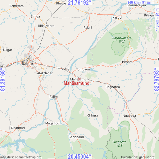
Mahāsamund GPS coordinates[2]
21° 6' 26.748" North, 82° 5' 41.28" East
| Map corner | latitude | longitude |
|---|---|---|
| Upper-left | 21.76192°, | 81.39168° |
| Center: | 21.10743°, | 82.0948° |
| Lower-right: | 20.45004°, | 82.79793° |
| Map W x H: | 145.9×145.9 km | = 90.7×90.7mi |
| max Lat: | 34.9274° ⇑61.2% North |
| Mahāsamund: | 21.10743° |
| min Lat: | ⇓38.8% South 8.09008° |
| min Long | Mahāsamund | max Long |
| 68.82655° | 82.0948° | 96.81° |
| W 76.9%⇐ | ⇒23.1% E |
Elevation
Elevation of Mahāsamund is 299 m = 981 ft, and this is 3.4 m = 11 ft above average elevation for this country.
| Max E: |
3681 m = 12077 ft | 33.4% |
| Mahāsamund | 299 m 981 ft | |
| Avg. | 295.6 m = 970 ft | |
Min E: |
1 m = 3 ft | 66.6% |
See also: Mahāsamund elevation on elevation.city.
Geographical zone
Mahāsamund is located in North Torrid zone (between Equator and Tropic of Cancer). Distance of this Northern Tropic circle is 259 km =160.9 mi to North.| Distance of | km | miles | from Mahāsamund |
|---|---|---|---|
| North Pole | 7660.1 | 4759.8 | to North |
| Arctic Circle | 5054.2 | 3140.5 | to North |
| Tropic Cancer | 259 | 160.9 | to North |
| Equator | 2346.9 | 1458.3 | to South |


Nearby cities:
15 places around Mahāsamund: (largest is in red/bold)
• Arang
16.4 km =10.2 mi,  307°
307°
• Baloda Bāzār
61.5 km =38.2 mi,  6°
6°
• Bhatgaon
41.2 km =25.6 mi,  276°
276°
• Bhilai
70 km =43.5 mi, 279°
• Bhātāpāra
71.4 km =44.4 mi,  347°
347°
• Deori
66.1 km =41.1 mi,  54°
54°
• Dhamtari
72.1 km =44.8 mi,  231°
231°
• Gariāband
52.8 km =32.8 mi,  183°
183°
• Khamharia
21.8 km =13.5 mi,  132°
132°
• Kumhāri
62.5 km =38.8 mi,  286°
286°
• Kurud
49.4 km =30.7 mi, 231°
• Pithora
46.6 km =29 mi,  70°
70°
• Pātan
58.8 km =36.5 mi,  261°
261°
• Raipur
49.9 km =31 mi, 286°
• Simga
70.6 km =43.9 mi,  325°
325°
Sources, notices
• [Note1] Compared only with cities in India existing in our database
• [Src1] Map data: © OpenStreetMap contributors (CC-BY-SA)
• [Src2] Other city data from geonames.org with taken over terms of usage.
• [Src3] Geographical zone / Annual Mean Temperature by Robert A. Rohde @ Wikipedia
