Purwā geodata
Purwā (Uttar Pradesh) is a populated place; located in India in Asia/Kolkata (GMT+5.5) time zone. With population of 22,220 people, there are 1889 cities with bigger population in this country. Compared to other cities in India, 74.2% of cities are located further ↓South; 72.1% of cities are located further ←West and 63.8% of cities have higher elevation than Purwā. Note1


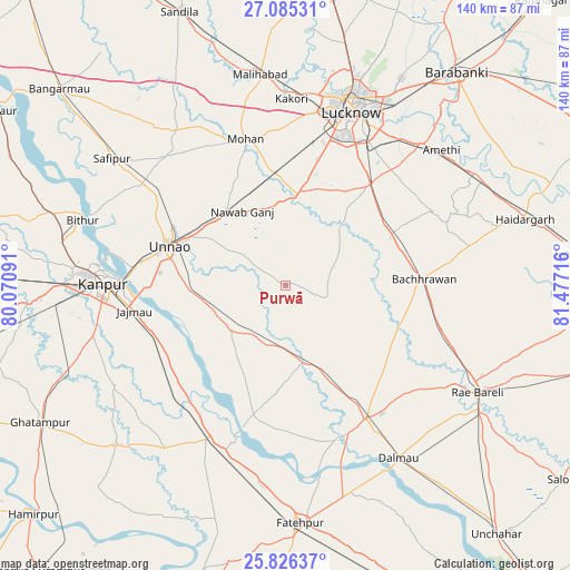
Purwā GPS coordinates[2]
26° 27' 27.216" North, 80° 46' 26.508" East
| Map corner | latitude | longitude |
|---|---|---|
| Upper-left | 27.08531°, | 80.07091° |
| Center: | 26.45756°, | 80.77403° |
| Lower-right: | 25.82637°, | 81.47716° |
| Map W x H: | 140×140 km | = 87×87mi |
| max Lat: | 34.9274° ⇑25.8% North |
| Purwā: | 26.45756° |
| min Lat: | ⇓74.2% South 8.09008° |
| min Long | Purwā | max Long |
| 68.82655° | 80.77403° | 96.81° |
| W 72.1%⇐ | ⇒27.9% E |
Elevation
Elevation of Purwā is 128 m = 420 ft, and this is 167.6 m = 550 ft below average elevation for this country.
| Max E: |
3681 m = 12077 ft | 63.8% |
| Avg. | 295.6 m = 970 ft | |
| Purwā | 128 m = 420 ft | |
Min E: |
1 m = 3 ft | 36.2% |
See also: India elevation on elevation.city.
Geographical zone
Purwā is located in North temperate zone (between Tropic of Cancer and the Arctic Circle). Distance of this Northern Tropic circle is 335.9 km =208.7 mi to South.| Distance of | km | miles | from Purwā |
|---|---|---|---|
| North Pole | 7065.3 | 4390.2 | to North |
| Arctic Circle | 4459.4 | 2770.9 | to North |
| Tropic Cancer | 335.9 | 208.7 | to South |
| Equator | 2941.8 | 1827.9 | to South |


Nearby cities:
15 places around Purwā: (largest is in red/bold)
• Bachhrāwān
34.1 km =21.2 mi,  87°
87°
• Bhagwantnagar
26 km =16.2 mi,  183°
183°
• Bīghāpur Khurd
16.9 km =10.5 mi,  223°
223°
• Goshāīnganj
47.9 km =29.8 mi,  43°
43°
• Jagdīshpur
39.7 km =24.7 mi,  324°
324°
• Kanpur
42.2 km =26.2 mi,  271°
271°
• Kākori
45.7 km =28.4 mi,  1°
1°
• Lucknow
45 km =28 mi,  19°
19°
• Mahārājganj
50.5 km =31.4 mi,  99°
99°
• Maurānwān
11 km =6.8 mi,  106°
106°
• Mohān
37.2 km =23.1 mi,  344°
344°
• Nagrām
40.6 km =25.2 mi,  63°
63°
• Nawābganj
46.5 km =28.9 mi,  275°
275°
• Rasūlābād
42.6 km =26.5 mi, 318°
• Unnāo
30.2 km =18.8 mi,  289°
289°
Sources, notices
• [Note1] Compared only with cities in India existing in our database
• [Src1] Map data: © OpenStreetMap contributors (CC-BY-SA)
• [Src2] Other city data from geonames.org with taken over terms of usage.
• [Src3] Geographical zone / Annual Mean Temperature by Robert A. Rohde @ Wikipedia
