Bīghāpur Khurd geodata
Bīghāpur Khurd (Uttar Pradesh) is a populated place; located in India in Asia/Kolkata (GMT+5.5) time zone. With population of 6,409 people, there are 3260 cities with bigger population in this country. Compared to other cities in India, 73.5% of cities are located further ↓South; 71.6% of cities are located further ←West and 64.3% of cities have higher elevation than Bīghāpur Khurd. Note1


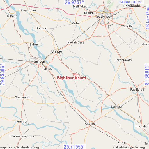
Bīghāpur Khurd GPS coordinates[2]
26° 20' 50.424" North, 80° 39' 25.128" East
| Map corner | latitude | longitude |
|---|---|---|
| Upper-left | 26.9757°, | 79.95386° |
| Center: | 26.34734°, | 80.65698° |
| Lower-right: | 25.71555°, | 81.36011° |
| Map W x H: | 140.1×140.1 km | = 87.1×87.1mi |
| max Lat: | 34.9274° ⇑26.5% North |
| Bīghāpur Khurd: | 26.34734° |
| min Lat: | ⇓73.5% South 8.09008° |
| min Long | Bīghāpur Khur | max Long |
| 68.82655° | 80.65698° | 96.81° |
| W 71.6%⇐ | ⇒28.4% E |
Elevation
Elevation of Bīghāpur Khurd is 125 m = 410 ft, and this is 170.6 m = 560 ft below average elevation for this country.
| Max E: |
3681 m = 12077 ft | 64.3% |
| Avg. | 295.6 m = 970 ft | |
| Bīghāpur Khurd | 125 m = 410 ft | |
Min E: |
1 m = 3 ft | 35.7% |
See also: India elevation on elevation.city.
Geographical zone
Bīghāpur Khurd is located in North temperate zone (between Tropic of Cancer and the Arctic Circle). Distance of this Northern Tropic circle is 323.6 km =201.1 mi to South.| Distance of | km | miles | from Bīghāpur Khurd |
|---|---|---|---|
| North Pole | 7077.5 | 4397.8 | to North |
| Arctic Circle | 4471.6 | 2778.5 | to North |
| Tropic Cancer | 323.6 | 201.1 | to South |
| Equator | 2929.5 | 1820.3 | to South |


Nearby cities:
15 places around Bīghāpur Khurd: (largest is in red/bold)
• Bachhrāwān
47.7 km =29.6 mi,  73°
73°
• Bhagwantnagar
17 km =10.6 mi,  143°
143°
• Bindki
35.5 km =22.1 mi,  193°
193°
• Bithūr
48 km =29.8 mi,  306°
306°
• Dalmau
48.7 km =30.3 mi,  130°
130°
• Fatehpur
49.2 km =30.6 mi,  161°
161°
• Ghātampur
53.3 km =33.1 mi,  246°
246°
• Jagdīshpur
46.1 km =28.6 mi,  346°
346°
• Kanpur
33.3 km =20.7 mi,  293°
293°
• Maurānwān
24 km =14.9 mi, 67°
• Mohān
48.1 km =29.9 mi,  2°
2°
• Nawābganj
38.4 km =23.9 mi,  295°
295°
• Purwā
16.9 km =10.5 mi,  43°
43°
• Rasūlābād
47.2 km =29.3 mi,  339°
339°
• Unnāo
27.9 km =17.3 mi,  322°
322°
Sources, notices
• [Note1] Compared only with cities in India existing in our database
• [Src1] Map data: © OpenStreetMap contributors (CC-BY-SA)
• [Src2] Other city data from geonames.org with taken over terms of usage.
• [Src3] Geographical zone / Annual Mean Temperature by Robert A. Rohde @ Wikipedia
