Bachhrāwān geodata
Bachhrāwān (Uttar Pradesh) is a populated place; located in India in Asia/Kolkata (GMT+5.5) time zone. With population of 12,809 people, there are 2672 cities with bigger population in this country. Compared to other cities in India, 74.4% of cities are located further ↓South; 73.4% of cities are located further ←West and 65% of cities have higher elevation than Bachhrāwān. Note1


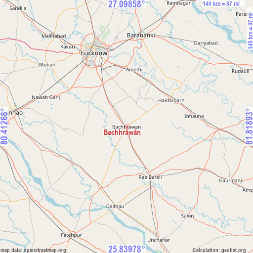
Bachhrāwān GPS coordinates[2]
26° 28' 15.24" North, 81° 6' 56.88" East
| Map corner | latitude | longitude |
|---|---|---|
| Upper-left | 27.09858°, | 80.41268° |
| Center: | 26.4709°, | 81.1158° |
| Lower-right: | 25.83978°, | 81.81893° |
| Map W x H: | 140×140 km | = 87×87mi |
| max Lat: | 34.9274° ⇑25.6% North |
| Bachhrāwān: | 26.4709° |
| min Lat: | ⇓74.4% South 8.09008° |
| min Long | Bachhrāwān | max Long |
| 68.82655° | 81.1158° | 96.81° |
| W 73.4%⇐ | ⇒26.6% E |
Elevation
Elevation of Bachhrāwān is 120 m = 394 ft, and this is 175.6 m = 576 ft below average elevation for this country.
| Max E: |
3681 m = 12077 ft | 65% |
| Avg. | 295.6 m = 970 ft | |
| Bachhrāwān | 120 m = 394 ft | |
Min E: |
1 m = 3 ft | 35% |
See also: India elevation on elevation.city.
Geographical zone
Bachhrāwān is located in North temperate zone (between Tropic of Cancer and the Arctic Circle). Distance of this Northern Tropic circle is 337.4 km =209.7 mi to South.| Distance of | km | miles | from Bachhrāwān |
|---|---|---|---|
| North Pole | 7063.8 | 4389.2 | to North |
| Arctic Circle | 4457.9 | 2770 | to North |
| Tropic Cancer | 337.4 | 209.7 | to South |
| Equator | 2943.3 | 1828.9 | to South |


Nearby cities:
15 places around Bachhrāwān: (largest is in red/bold)
• Bhagwantnagar
45 km =28 mi,  232°
232°
• Bīghāpur Khurd
47.7 km =29.6 mi,  253°
253°
• Dalmau
46 km =28.6 mi,  190°
190°
• Goshāīnganj
33 km =20.5 mi,  358°
358°
• Jais
48.8 km =30.3 mi,  117°
117°
• Kākori
55 km =34.2 mi,  323°
323°
• Lucknow
45.2 km =28.1 mi,  334°
334°
• Mahārājganj
18.7 km =11.6 mi, 122°
• Maurānwān
23.9 km =14.9 mi,  258°
258°
• Nagrām
16.6 km =10.3 mi,  8°
8°
• Nawābganj
51.8 km =32.2 mi, 9°
• Purwā
34.1 km =21.2 mi,  267°
267°
• Raebareli
29.1 km =18.1 mi,  156°
156°
• Satrikh
44 km =27.3 mi, 10°
• Zaidpur
45.3 km =28.1 mi,  27°
27°
Sources, notices
• [Note1] Compared only with cities in India existing in our database
• [Src1] Map data: © OpenStreetMap contributors (CC-BY-SA)
• [Src2] Other city data from geonames.org with taken over terms of usage.
• [Src3] Geographical zone / Annual Mean Temperature by Robert A. Rohde @ Wikipedia
