Mahārājganj geodata
Mahārājganj (Uttar Pradesh) is a populated place; located in India in Asia/Kolkata (GMT+5.5) time zone. With population of 6,442 people, there are 3258 cities with bigger population in this country. Compared to other cities in India, 73.7% of cities are located further ↓South; 73.9% of cities are located further ←West and 64.6% of cities have higher elevation than Mahārājganj. Note1


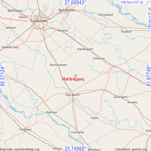
Mahārājganj GPS coordinates[2]
26° 22' 52.536" North, 81° 16' 27.696" East
| Map corner | latitude | longitude |
|---|---|---|
| Upper-left | 27.00943°, | 80.57124° |
| Center: | 26.38126°, | 81.27436° |
| Lower-right: | 25.74965°, | 81.97749° |
| Map W x H: | 140.1×140.1 km | = 87.1×87.1mi |
| max Lat: | 34.9274° ⇑26.3% North |
| Mahārājganj: | 26.38126° |
| min Lat: | ⇓73.7% South 8.09008° |
| min Long | Mahārājganj | max Long |
| 68.82655° | 81.27436° | 96.81° |
| W 73.9%⇐ | ⇒26.1% E |
Elevation
Elevation of Mahārājganj is 123 m = 404 ft, and this is 172.6 m = 566 ft below average elevation for this country.
| Max E: |
3681 m = 12077 ft | 64.6% |
| Avg. | 295.6 m = 970 ft | |
| Mahārājganj | 123 m = 404 ft | |
Min E: |
1 m = 3 ft | 35.4% |
See also: India elevation on elevation.city.
Geographical zone
Mahārājganj is located in North temperate zone (between Tropic of Cancer and the Arctic Circle). Distance of this Northern Tropic circle is 327.4 km =203.4 mi to South.| Distance of | km | miles | from Mahārājganj |
|---|---|---|---|
| North Pole | 7073.7 | 4395.4 | to North |
| Arctic Circle | 4467.9 | 2776.2 | to North |
| Tropic Cancer | 327.4 | 203.4 | to South |
| Equator | 2933.3 | 1822.7 | to South |


Nearby cities:
15 places around Mahārājganj: (largest is in red/bold)
• Amethī
58.5 km =36.4 mi,  115°
115°
• Bachhrāwān
18.7 km =11.6 mi,  302°
302°
• Bhagwantnagar
54.4 km =33.8 mi,  251°
251°
• Dalmau
42.8 km =26.6 mi,  214°
214°
• Goshāīnganj
46.1 km =28.6 mi,  338°
338°
• Jais
30.2 km =18.8 mi, 115°
• Maurānwān
39.6 km =24.6 mi,  277°
277°
• Musāfir-Khāna
52 km =32.3 mi,  90°
90°
• Nagrām
29.6 km =18.4 mi,  333°
333°
• Parshādepur
40.5 km =25.2 mi,  147°
147°
• Purwā
50.5 km =31.4 mi, 279°
• Raebareli
17.2 km =10.7 mi,  193°
193°
• Salon
43.1 km =26.8 mi,  155°
155°
• Satrikh
53.9 km =33.5 mi,  351°
351°
• Zaidpur
50.3 km =31.3 mi,  6°
6°
Sources, notices
• [Note1] Compared only with cities in India existing in our database
• [Src1] Map data: © OpenStreetMap contributors (CC-BY-SA)
• [Src2] Other city data from geonames.org with taken over terms of usage.
• [Src3] Geographical zone / Annual Mean Temperature by Robert A. Rohde @ Wikipedia
