Khandwa geodata
Khandwa (Madhya Pradesh) is a populated place; located in India in Asia/Kolkata (GMT+5.5) time zone. With population of 182,841 people, there are 232 cities with bigger population in this country. Compared to other cities in India, 57.4% of cities are located further ↑North; 69.8% of cities are located further →East and 68.8% of cities have lower elevation than Khandwa. Note1


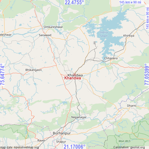
Khandwa GPS coordinates[2]
21° 49' 27.372" North, 76° 21' 3.096" East
| Map corner | latitude | longitude |
|---|---|---|
| Upper-left | 22.4755°, | 75.64774° |
| Center: | 21.82427°, | 76.35086° |
| Lower-right: | 21.17006°, | 77.05399° |
| Map W x H: | 145.2×145.2 km | = 90.2×90.2mi |
| max Lat: | 34.9274° ⇑57.4% North |
| Khandwa: | 21.82427° |
| min Lat: | ⇓42.6% South 8.09008° |
| min Long | Khandwa | max Long |
| 68.82655° | 76.35086° | 96.81° |
| W 30.2%⇐ | ⇒69.8% E |
Elevation
Elevation of Khandwa is 314 m = 1030 ft, and this is 18.4 m = 60 ft above average elevation for this country.
| Max E: |
3681 m = 12077 ft | 31.2% |
| Khandwa | 314 m 1030 ft | |
| Avg. | 295.6 m = 970 ft | |
Min E: |
1 m = 3 ft | 68.8% |
See also: Khandwa elevation on elevation.city.
Geographical zone
Khandwa is located in North Torrid zone (between Equator and Tropic of Cancer). Distance of this Northern Tropic circle is 179.3 km =111.4 mi to North.| Distance of | km | miles | from Khandwa |
|---|---|---|---|
| North Pole | 7580.4 | 4710.2 | to North |
| Arctic Circle | 4974.5 | 3091 | to North |
| Tropic Cancer | 179.3 | 111.4 | to North |
| Equator | 2426.6 | 1507.8 | to South |


Nearby cities:
15 places around Khandwa: (largest is in red/bold)
• Bhikangaon
40.2 km =25 mi,  276°
276°
• Burhānpur
58.7 km =36.5 mi,  192°
192°
• Harsūd
50 km =31.1 mi,  52°
52°
• Kasrāwad
83.4 km =51.8 mi,  293°
293°
• Khargone
76.1 km =47.3 mi,  269°
269°
• Khirkiyān
65 km =40.4 mi, 54°
• Mundi
30.7 km =19.1 mi,  28°
28°
• Māndleshwar
81.3 km =50.5 mi,  298°
298°
• Nepānagar
41.4 km =25.7 mi,  173°
173°
• Pandhāna
19.1 km =11.9 mi,  222°
222°
• Punāsa
45.9 km =28.5 mi,  5°
5°
• Rāver
72 km =44.7 mi,  206°
206°
• Sanāwad
48.5 km =30.1 mi,  323°
323°
• Satwās
86.3 km =53.6 mi,  23°
23°
• Shāhpur
66.5 km =41.3 mi, 191°
Sources, notices
• [Note1] Compared only with cities in India existing in our database
• [Src1] Map data: © OpenStreetMap contributors (CC-BY-SA)
• [Src2] Other city data from geonames.org with taken over terms of usage.
• [Src3] Geographical zone / Annual Mean Temperature by Robert A. Rohde @ Wikipedia
