Pandhāna geodata
Pandhāna (Madhya Pradesh) is a populated place; located in India in Asia/Kolkata (GMT+5.5) time zone. With population of 11,626 people, there are 2772 cities with bigger population in this country. Compared to other cities in India, 58% of cities are located further ↑North; 71.4% of cities are located further →East and 73.3% of cities have lower elevation than Pandhāna. Note1


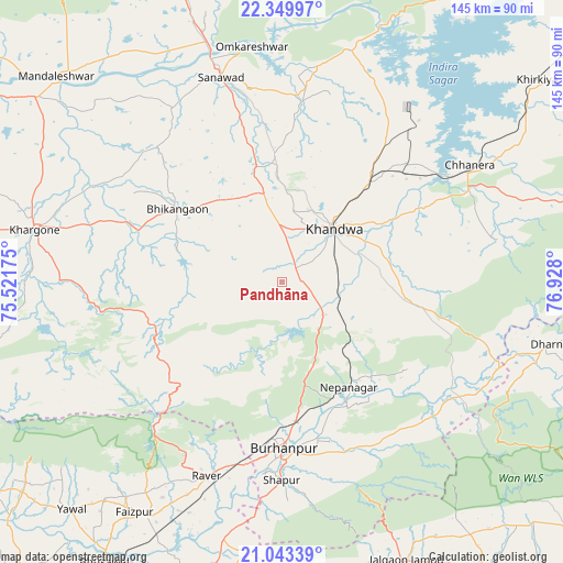
Pandhāna GPS coordinates[2]
21° 41' 53.376" North, 76° 13' 29.532" East
| Map corner | latitude | longitude |
|---|---|---|
| Upper-left | 22.34997°, | 75.52175° |
| Center: | 21.69816°, | 76.22487° |
| Lower-right: | 21.04339°, | 76.928° |
| Map W x H: | 145.3×145.3 km | = 90.3×90.3mi |
| max Lat: | 34.9274° ⇑58% North |
| Pandhāna: | 21.69816° |
| min Lat: | ⇓42% South 8.09008° |
| min Long | Pandhāna | max Long |
| 68.82655° | 76.22487° | 96.81° |
| W 28.6%⇐ | ⇒71.4% E |
Elevation
Elevation of Pandhāna is 364 m = 1194 ft, and this is 68.4 m = 224 ft above average elevation for this country.
| Max E: |
3681 m = 12077 ft | 26.7% |
| Pandhāna | 364 m 1194 ft | |
| Avg. | 295.6 m = 970 ft | |
Min E: |
1 m = 3 ft | 73.3% |
See also: India elevation on elevation.city.
Geographical zone
Pandhāna is located in North Torrid zone (between Equator and Tropic of Cancer). Distance of this Northern Tropic circle is 193.3 km =120.1 mi to North.| Distance of | km | miles | from Pandhāna |
|---|---|---|---|
| North Pole | 7594.5 | 4719 | to North |
| Arctic Circle | 4988.6 | 3099.8 | to North |
| Tropic Cancer | 193.3 | 120.1 | to North |
| Equator | 2412.6 | 1499.1 | to South |


Nearby cities:
15 places around Pandhāna: (largest is in red/bold)
• Bhikangaon
32.9 km =20.4 mi,  304°
304°
• Burhānpur
43.3 km =26.9 mi,  179°
179°
• Faizpur
70 km =43.5 mi,  212°
212°
• Harsūd
68.9 km =42.8 mi,  49°
49°
• Jalgaon Jamod
78.7 km =48.9 mi,  155°
155°
• Khandwa
19.1 km =11.9 mi,  42°
42°
• Khargone
64.6 km =40.1 mi,  282°
282°
• Mundi
49.5 km =30.8 mi,  34°
34°
• Māndleshwar
78.9 km =49 mi,  312°
312°
• Nepānagar
32.3 km =20.1 mi,  147°
147°
• Punāsa
62.2 km =38.6 mi,  16°
16°
• Rāver
53.8 km =33.4 mi,  201°
201°
• Sanāwad
55.3 km =34.4 mi,  343°
343°
• Shāhpur
51.2 km =31.8 mi, 179°
• Sāvda
70.1 km =43.6 mi, 209°
Sources, notices
• [Note1] Compared only with cities in India existing in our database
• [Src1] Map data: © OpenStreetMap contributors (CC-BY-SA)
• [Src2] Other city data from geonames.org with taken over terms of usage.
• [Src3] Geographical zone / Annual Mean Temperature by Robert A. Rohde @ Wikipedia
