Shikohābād geodata
Shikohābād (Uttar Pradesh) is a populated place; located in India in Asia/Kolkata (GMT+5.5) time zone. With population of 99,678 people, there are 442 cities with bigger population in this country. Compared to other cities in India, 79.3% of cities are located further ↓South; 55% of cities are located further ←West and 56.9% of cities have higher elevation than Shikohābād. Note1


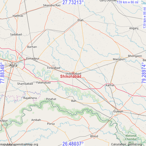
Shikohābād GPS coordinates[2]
27° 6' 28.8" North, 78° 35' 11.796" East
| Map corner | latitude | longitude |
|---|---|---|
| Upper-left | 27.73213°, | 77.88349° |
| Center: | 27.108°, | 78.58661° |
| Lower-right: | 26.48037°, | 79.28974° |
| Map W x H: | 139.2×139.2 km | = 86.5×86.5mi |
| max Lat: | 34.9274° ⇑20.7% North |
| Shikohābād: | 27.108° |
| min Lat: | ⇓79.3% South 8.09008° |
| min Long | Shikohābād | max Long |
| 68.82655° | 78.58661° | 96.81° |
| W 55%⇐ | ⇒45% E |
Elevation
Elevation of Shikohābād is 165 m = 541 ft, and this is 130.6 m = 428 ft below average elevation for this country.
| Max E: |
3681 m = 12077 ft | 56.9% |
| Avg. | 295.6 m = 970 ft | |
| Shikohābād | 165 m = 541 ft | |
Min E: |
1 m = 3 ft | 43.1% |
See also: Shikohābād elevation on elevation.city.
Geographical zone
Shikohābād is located in North temperate zone (between Tropic of Cancer and the Arctic Circle). Distance of this Northern Tropic circle is 408.2 km =253.6 mi to South.| Distance of | km | miles | from Shikohābād |
|---|---|---|---|
| North Pole | 6992.9 | 4345.2 | to North |
| Arctic Circle | 4387 | 2726 | to North |
| Tropic Cancer | 408.2 | 253.6 | to South |
| Equator | 3014.1 | 1872.9 | to South |


Nearby cities:
15 places around Shikohābād: (largest is in red/bold)
• Bāh
26.6 km =16.5 mi,  178°
178°
• Fatehābād
29.5 km =18.3 mi,  252°
252°
• Fīrozābād
19.3 km =12 mi,  284°
284°
• Ghiror
22.3 km =13.9 mi,  66°
66°
• Itimādpur
40.9 km =25.4 mi,  290°
290°
• Jasrāna
15.6 km =9.7 mi,  24°
24°
• Jaswantnagar
40.1 km =24.9 mi,  128°
128°
• Karhal
36.9 km =22.9 mi,  108°
108°
• Mainpuri
45.8 km =28.5 mi, 72°
• Pharihā
26.3 km =16.3 mi,  334°
334°
• Pināhat
32.4 km =20.1 mi,  220°
220°
• Sakīt
41 km =25.5 mi,  27°
27°
• Shamsābād
46.9 km =29.1 mi,  257°
257°
• Sirsāganj
11.4 km =7.1 mi,  119°
119°
• Tūndla
36.6 km =22.7 mi, 288°
Sources, notices
• [Note1] Compared only with cities in India existing in our database
• [Src1] Map data: © OpenStreetMap contributors (CC-BY-SA)
• [Src2] Other city data from geonames.org with taken over terms of usage.
• [Src3] Geographical zone / Annual Mean Temperature by Robert A. Rohde @ Wikipedia
