Bhind geodata
Bhind (Madhya Pradesh) is a populated place; located in India in Asia/Kolkata (GMT+5.5) time zone. With population of 174,035 people, there are 246 cities with bigger population in this country. Compared to other cities in India, 75.2% of cities are located further ↓South; 56.9% of cities are located further ←West and 58.3% of cities have higher elevation than Bhind. Note1


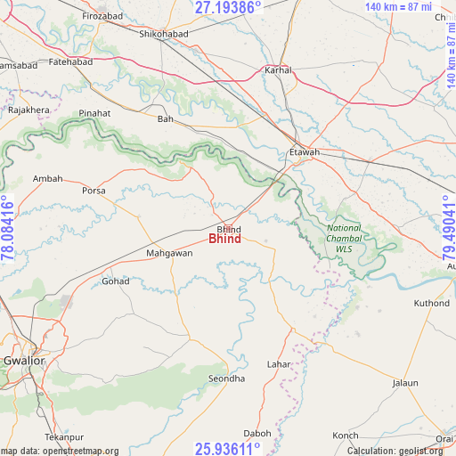
Bhind GPS coordinates[2]
26° 34' 0.156" North, 78° 47' 14.208" East
| Map corner | latitude | longitude |
|---|---|---|
| Upper-left | 27.19386°, | 78.08416° |
| Center: | 26.56671°, | 78.78728° |
| Lower-right: | 25.93611°, | 79.49041° |
| Map W x H: | 139.8×139.9 km | = 86.9×86.9mi |
| max Lat: | 34.9274° ⇑24.8% North |
| Bhind: | 26.56671° |
| min Lat: | ⇓75.2% South 8.09008° |
| min Long | Bhind | max Long |
| 68.82655° | 78.78728° | 96.81° |
| W 56.9%⇐ | ⇒43.1% E |
Elevation
Elevation of Bhind is 157 m = 515 ft, and this is 138.6 m = 455 ft below average elevation for this country.
| Max E: |
3681 m = 12077 ft | 58.3% |
| Avg. | 295.6 m = 970 ft | |
| Bhind | 157 m = 515 ft | |
Min E: |
1 m = 3 ft | 41.7% |
See also: Bhind elevation on elevation.city.
Geographical zone
Bhind is located in North temperate zone (between Tropic of Cancer and the Arctic Circle). Distance of this Northern Tropic circle is 348 km =216.2 mi to South.| Distance of | km | miles | from Bhind |
|---|---|---|---|
| North Pole | 7053.1 | 4382.6 | to North |
| Arctic Circle | 4447.2 | 2763.4 | to North |
| Tropic Cancer | 348 | 216.2 | to South |
| Equator | 2953.9 | 1835.5 | to South |


Nearby cities:
15 places around Bhind: (largest is in red/bold)
• Bakewar
40.1 km =24.9 mi,  74°
74°
• Bāh
38.7 km =24 mi,  330°
330°
• Etāwah
32.9 km =20.4 mi,  44°
44°
• Gohadi
37.4 km =23.2 mi,  246°
246°
• Jaswantnagar
37 km =23 mi,  18°
18°
• Lahār
44.2 km =27.5 mi,  159°
159°
• Lakhnā
37 km =23 mi,  75°
75°
• Mahgawān
18.8 km =11.7 mi,  244°
244°
• Mau
35.4 km =22 mi,  199°
199°
• Mihona
36.9 km =22.9 mi,  148°
148°
• Porsa
43.1 km =26.8 mi,  286°
286°
• Rāmpura
46.1 km =28.6 mi,  121°
121°
• Sarai Ekdil
36.3 km =22.6 mi,  57°
57°
• Seondha
45.9 km =28.5 mi,  180°
180°
• Umri
16.1 km =10 mi,  112°
112°
Sources, notices
• [Note1] Compared only with cities in India existing in our database
• [Src1] Map data: © OpenStreetMap contributors (CC-BY-SA)
• [Src2] Other city data from geonames.org with taken over terms of usage.
• [Src3] Geographical zone / Annual Mean Temperature by Robert A. Rohde @ Wikipedia
