Coimbatore geodata
Coimbatore (Tamil Nadu) is a populated place; located in India in Asia/Kolkata (GMT+5.5) time zone. With population of 959,823 people, there are 45 cities with bigger population in this country. Compared to other cities in India, 93.1% of cities are located further ↑North; 63.5% of cities are located further →East and 77.6% of cities have lower elevation than Coimbatore. Note1


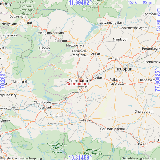
Coimbatore GPS coordinates[2]
11° 0' 19.98" North, 76° 57' 58.032" East
| Map corner | latitude | longitude |
|---|---|---|
| Upper-left | 11.69492°, | 76.263° |
| Center: | 11.00555°, | 76.96612° |
| Lower-right: | 10.31456°, | 77.66925° |
| Map W x H: | 153.5×153.5 km | = 95.4×95.4mi |
| max Lat: | 34.9274° ⇑93.1% North |
| Coimbatore: | 11.00555° |
| min Lat: | ⇓6.9% South 8.09008° |
| min Long | Coimbatore | max Long |
| 68.82655° | 76.96612° | 96.81° |
| W 36.5%⇐ | ⇒63.5% E |
Elevation
Elevation of Coimbatore is 425 m = 1394 ft, and this is 129.4 m = 425 ft above average elevation for this country.
| Max E: |
3681 m = 12077 ft | 22.4% |
| Coimbatore | 425 m 1394 ft | |
| Avg. | 295.6 m = 970 ft | |
Min E: |
1 m = 3 ft | 77.6% |
See also: Coimbatore elevation on elevation.city.
Geographical zone
Coimbatore is located in North Torrid zone (between Equator and Tropic of Cancer). Distance of Equator is 1223.7 km =760.4 mi to South.| Distance of | km | miles | from Coimbatore |
|---|---|---|---|
| North Pole | 8783.4 | 5457.8 | to North |
| Arctic Circle | 6177.5 | 3838.5 | to North |
| Tropic Cancer | 1382.2 | 858.9 | to North |
| Equator | 1223.7 | 760.4 | to South |


Nearby cities:
15 places around Coimbatore: (largest is in red/bold)
• Annur
29.8 km =18.5 mi,  30°
30°
• Avinashi
39 km =24.2 mi,  57°
57°
• Chettipālaiyam
12.9 km =8 mi,  143°
143°
• Irugūr
10.6 km =6.6 mi,  82°
82°
• Kāramadai
26.1 km =16.2 mi,  358°
358°
• Madukkarai
11.1 km =6.9 mi,  181°
181°
• Mettupalayam
32.9 km =20.4 mi,  354°
354°
• Palladam
35 km =21.7 mi,  92°
92°
• Periyanayakkanpalaiyam
16.4 km =10.2 mi, 354°
• Periyanegamam
32.8 km =20.4 mi,  152°
152°
• Perūr
6.7 km =4.2 mi,  239°
239°
• Pollachi
38.9 km =24.2 mi,  173°
173°
• Singānallūr
7.3 km =4.5 mi,  95°
95°
• Sirumugai
35.4 km =22 mi,  6°
6°
• Sulur
17.5 km =10.9 mi, 83°
Sources, notices
• [Note1] Compared only with cities in India existing in our database
• [Src1] Map data: © OpenStreetMap contributors (CC-BY-SA)
• [Src2] Other city data from geonames.org with taken over terms of usage.
• [Src3] Geographical zone / Annual Mean Temperature by Robert A. Rohde @ Wikipedia
