Singānallūr geodata
Singānallūr (Tamil Nadu) is a populated place; located in India in Asia/Kolkata (GMT+5.5) time zone. With population of 31,239 people, there are 1388 cities with bigger population in this country. Compared to other cities in India, 93.2% of cities are located further ↑North; 62.8% of cities are located further →East and 75.7% of cities have lower elevation than Singānallūr. Note1


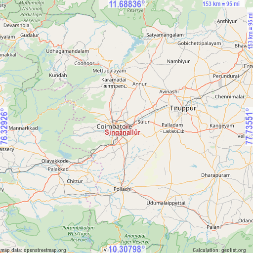
Singānallūr GPS coordinates[2]
10° 59' 56.328" North, 77° 1' 56.568" East
| Map corner | latitude | longitude |
|---|---|---|
| Upper-left | 11.68836°, | 76.32926° |
| Center: | 10.99898°, | 77.03238° |
| Lower-right: | 10.30798°, | 77.73551° |
| Map W x H: | 153.5×153.5 km | = 95.4×95.4mi |
| max Lat: | 34.9274° ⇑93.2% North |
| Singānallūr: | 10.99898° |
| min Lat: | ⇓6.8% South 8.09008° |
| min Long | Singānallūr | max Long |
| 68.82655° | 77.03238° | 96.81° |
| W 37.2%⇐ | ⇒62.8% E |
Elevation
Elevation of Singānallūr is 395 m = 1296 ft, and this is 99.4 m = 326 ft above average elevation for this country.
| Max E: |
3681 m = 12077 ft | 24.3% |
| Singānallūr | 395 m 1296 ft | |
| Avg. | 295.6 m = 970 ft | |
Min E: |
1 m = 3 ft | 75.7% |
See also: India elevation on elevation.city.
Geographical zone
Singānallūr is located in North Torrid zone (between Equator and Tropic of Cancer). Distance of Equator is 1223 km =759.9 mi to South.| Distance of | km | miles | from Singānallūr |
|---|---|---|---|
| North Pole | 8784.1 | 5458.2 | to North |
| Arctic Circle | 6178.2 | 3839 | to North |
| Tropic Cancer | 1382.9 | 859.3 | to North |
| Equator | 1223 | 759.9 | to South |


Nearby cities:
15 places around Singānallūr: (largest is in red/bold)
• Annur
27.5 km =17.1 mi,  16°
16°
• Avinashi
33.6 km =20.9 mi,  50°
50°
• Chettipālaiyam
9.6 km =6 mi,  177°
177°
• Coimbatore
7.3 km =4.5 mi,  275°
275°
• Irugūr
3.9 km =2.4 mi,  57°
57°
• Kāramadai
28 km =17.4 mi,  343°
343°
• Madukkarai
12.8 km =8 mi,  215°
215°
• Mettupalayam
35.1 km =21.8 mi, 342°
• Palladam
27.7 km =17.2 mi,  91°
91°
• Periyanayakkanpalaiyam
19.2 km =11.9 mi,  332°
332°
• Periyanegamam
29.5 km =18.3 mi,  164°
164°
• Periyapatti
37.4 km =23.2 mi,  135°
135°
• Perūr
13.3 km =8.3 mi,  258°
258°
• Sirumugai
36 km =22.4 mi,  355°
355°
• Sulur
10.6 km =6.6 mi,  74°
74°
Sources, notices
• [Note1] Compared only with cities in India existing in our database
• [Src1] Map data: © OpenStreetMap contributors (CC-BY-SA)
• [Src2] Other city data from geonames.org with taken over terms of usage.
• [Src3] Geographical zone / Annual Mean Temperature by Robert A. Rohde @ Wikipedia
