Ujjain geodata
Ujjain (Madhya Pradesh) is a populated place; located in India in Asia/Kolkata (GMT+5.5) time zone. With population of 457,346 people, there are 97 cities with bigger population in this country. Compared to other cities in India, 52.8% of cities are located further ↓South; 76% of cities are located further →East and 82.1% of cities have lower elevation than Ujjain. Note1


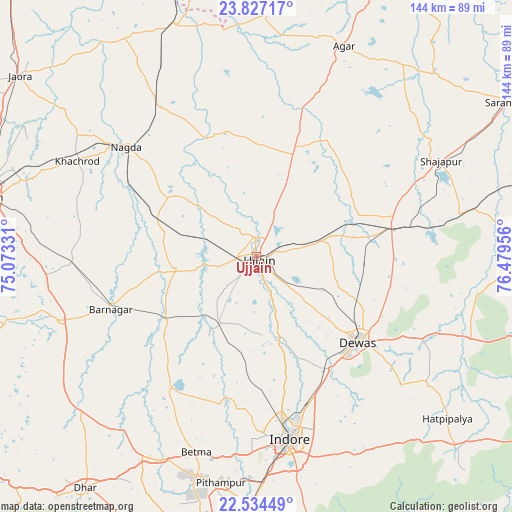
Ujjain GPS coordinates[2]
23° 10' 56.604" North, 75° 46' 35.148" East
| Map corner | latitude | longitude |
|---|---|---|
| Upper-left | 23.82717°, | 75.07331° |
| Center: | 23.18239°, | 75.77643° |
| Lower-right: | 22.53449°, | 76.47956° |
| Map W x H: | 143.7×143.7 km | = 89.3×89.3mi |
| max Lat: | 34.9274° ⇑47.2% North |
| Ujjain: | 23.18239° |
| min Lat: | ⇓52.8% South 8.09008° |
| min Long | Ujjain | max Long |
| 68.82655° | 75.77643° | 96.81° |
| W 24%⇐ | ⇒76% E |
Elevation
Elevation of Ujjain is 494 m = 1621 ft, and this is 198.4 m = 651 ft above average elevation for this country.
| Max E: |
3681 m = 12077 ft | 17.9% |
| Ujjain | 494 m 1621 ft | |
| Avg. | 295.6 m = 970 ft | |
Min E: |
1 m = 3 ft | 82.1% |
See also: Ujjain elevation on elevation.city.
Geographical zone
Ujjain is located in North Torrid zone (between Equator and Tropic of Cancer). Distance of this Northern Tropic circle is 28.3 km =17.6 mi to North.| Distance of | km | miles | from Ujjain |
|---|---|---|---|
| North Pole | 7429.4 | 4616.4 | to North |
| Arctic Circle | 4823.5 | 2997.2 | to North |
| Tropic Cancer | 28.3 | 17.6 | to North |
| Equator | 2577.6 | 1601.6 | to South |


Nearby cities:
15 places around Ujjain: (largest is in red/bold)
• Betma
57.6 km =35.8 mi,  196°
196°
• Depālpur
44 km =27.3 mi,  213°
213°
• Dewas
37.3 km =23.2 mi,  130°
130°
• Gautampura
34.1 km =21.2 mi,  230°
230°
• Gogāpur
49.4 km =30.7 mi,  327°
327°
• Hātod
43.4 km =27 mi,  185°
185°
• Indore
52 km =32.3 mi,  173°
173°
• Khāchrod
57.2 km =35.5 mi,  297°
297°
• Maksi
38.7 km =24 mi,  77°
77°
• Nagda
47.8 km =29.7 mi,  309°
309°
• Piploda
39.7 km =24.7 mi, 298°
• Shājāpur
57.9 km =36 mi,  62°
62°
• Sānwer
23.7 km =14.7 mi, 167°
• Tarāna
32 km =19.9 mi, 58°
• Unhel
28.1 km =17.5 mi, 307°
Sources, notices
• [Note1] Compared only with cities in India existing in our database
• [Src1] Map data: © OpenStreetMap contributors (CC-BY-SA)
• [Src2] Other city data from geonames.org with taken over terms of usage.
• [Src3] Geographical zone / Annual Mean Temperature by Robert A. Rohde @ Wikipedia
