Pihānī geodata
Pihānī (Uttar Pradesh) is a populated place; located in India in Asia/Kolkata (GMT+5.5) time zone. With population of 30,369 people, there are 1426 cities with bigger population in this country. Compared to other cities in India, 82.7% of cities are located further ↓South; 69.7% of cities are located further ←West and 59.9% of cities have higher elevation than Pihānī. Note1


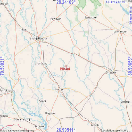
Pihānī GPS coordinates[2]
27° 37' 11.532" North, 80° 12' 12.348" East
| Map corner | latitude | longitude |
|---|---|---|
| Upper-left | 28.24109°, | 79.50031° |
| Center: | 27.61987°, | 80.20343° |
| Lower-right: | 26.99511°, | 80.90656° |
| Map W x H: | 138.5×138.5 km | = 86.1×86.1mi |
| max Lat: | 34.9274° ⇑17.3% North |
| Pihānī: | 27.61987° |
| min Lat: | ⇓82.7% South 8.09008° |
| min Long | Pihānī | max Long |
| 68.82655° | 80.20343° | 96.81° |
| W 69.7%⇐ | ⇒30.3% E |
Elevation
Elevation of Pihānī is 149 m = 489 ft, and this is 146.6 m = 481 ft below average elevation for this country.
| Max E: |
3681 m = 12077 ft | 59.9% |
| Avg. | 295.6 m = 970 ft | |
| Pihānī | 149 m = 489 ft | |
Min E: |
1 m = 3 ft | 40.1% |
See also: India elevation on elevation.city.
Geographical zone
Pihānī is located in North temperate zone (between Tropic of Cancer and the Arctic Circle). Distance of this Northern Tropic circle is 465.1 km =289 mi to South.| Distance of | km | miles | from Pihānī |
|---|---|---|---|
| North Pole | 6936 | 4309.8 | to North |
| Arctic Circle | 4330.1 | 2690.6 | to North |
| Tropic Cancer | 465.1 | 289 | to South |
| Equator | 3071 | 1908.2 | to South |


Nearby cities:
15 places around Pihānī: (largest is in red/bold)
• Allāhganj
51.5 km =32 mi,  260°
260°
• Benīganj
43.4 km =27 mi,  146°
146°
• Bilgrām
52.3 km =32.5 mi,  198°
198°
• Gopāmau
12.4 km =7.7 mi,  139°
139°
• Hardoī
26 km =16.2 mi, 195°
• Jalālābād
55.3 km =34.4 mi,  282°
282°
• Khairābād
55.3 km =34.4 mi,  100°
100°
• Kānt
45.7 km =28.4 mi,  297°
297°
• Maholi
27.1 km =16.8 mi,  79°
79°
• Misrikh
38.6 km =24 mi,  122°
122°
• Pawāyan
50.6 km =31.4 mi,  348°
348°
• Shāhjānpur
41.1 km =25.5 mi,  315°
315°
• Shāhābād
26.1 km =16.2 mi, 275°
• Sāndi
44.4 km =27.6 mi,  213°
213°
• Sītāpur
47.7 km =29.6 mi, 97°
Sources, notices
• [Note1] Compared only with cities in India existing in our database
• [Src1] Map data: © OpenStreetMap contributors (CC-BY-SA)
• [Src2] Other city data from geonames.org with taken over terms of usage.
• [Src3] Geographical zone / Annual Mean Temperature by Robert A. Rohde @ Wikipedia
