Bilgrām geodata
Bilgrām (Uttar Pradesh) is a populated place; located in India in Asia/Kolkata (GMT+5.5) time zone. With population of 27,173 people, there are 1579 cities with bigger population in this country. Compared to other cities in India, 79.9% of cities are located further ↓South; 68% of cities are located further ←West and 60.4% of cities have higher elevation than Bilgrām. Note1


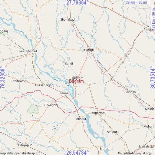
Bilgrām GPS coordinates[2]
27° 10' 30.324" North, 80° 1' 55.236" East
| Map corner | latitude | longitude |
|---|---|---|
| Upper-left | 27.79884°, | 79.32889° |
| Center: | 27.17509°, | 80.03201° |
| Lower-right: | 26.54784°, | 80.73514° |
| Map W x H: | 139.1×139.1 km | = 86.4×86.4mi |
| max Lat: | 34.9274° ⇑20.1% North |
| Bilgrām: | 27.17509° |
| min Lat: | ⇓79.9% South 8.09008° |
| min Long | Bilgrām | max Long |
| 68.82655° | 80.03201° | 96.81° |
| W 68%⇐ | ⇒32% E |
Elevation
Elevation of Bilgrām is 146 m = 479 ft, and this is 149.6 m = 491 ft below average elevation for this country.
| Max E: |
3681 m = 12077 ft | 60.4% |
| Avg. | 295.6 m = 970 ft | |
| Bilgrām | 146 m = 479 ft | |
Min E: |
1 m = 3 ft | 39.6% |
See also: India elevation on elevation.city.
Geographical zone
Bilgrām is located in North temperate zone (between Tropic of Cancer and the Arctic Circle). Distance of this Northern Tropic circle is 415.7 km =258.3 mi to South.| Distance of | km | miles | from Bilgrām |
|---|---|---|---|
| North Pole | 6985.5 | 4340.6 | to North |
| Arctic Circle | 4379.6 | 2721.4 | to North |
| Tropic Cancer | 415.7 | 258.3 | to South |
| Equator | 3021.6 | 1877.5 | to South |


Nearby cities:
15 places around Bilgrām: (largest is in red/bold)
• Benīganj
42.8 km =26.6 mi,  72°
72°
• Bilhaur
37 km =23 mi,  175°
175°
• Bāngarmau
36.2 km =22.5 mi,  150°
150°
• Fatehgarh
44.8 km =27.8 mi,  297°
297°
• Fatehpur Chaurāsi
48.7 km =30.3 mi, 151°
• Ganj Murādābād
28.5 km =17.7 mi, 148°
• Gopāmau
47.2 km =29.3 mi,  32°
32°
• Gursahāiganj
30.4 km =18.9 mi,  257°
257°
• Hardoī
26.4 km =16.4 mi,  21°
21°
• Indergarh
44.6 km =27.7 mi,  233°
233°
• Kamalganj
40.8 km =25.4 mi,  283°
283°
• Kannauj
17.4 km =10.8 mi,  220°
220°
• Mādhoganj
12.5 km =7.8 mi,  120°
120°
• Sāndi
14.9 km =9.3 mi,  327°
327°
• Tālgrām
40.6 km =25.2 mi,  249°
249°
Sources, notices
• [Note1] Compared only with cities in India existing in our database
• [Src1] Map data: © OpenStreetMap contributors (CC-BY-SA)
• [Src2] Other city data from geonames.org with taken over terms of usage.
• [Src3] Geographical zone / Annual Mean Temperature by Robert A. Rohde @ Wikipedia
