Kānt geodata
Kānt (Uttar Pradesh) is a populated place; located in India in Asia/Kolkata (GMT+5.5) time zone. With population of 24,430 people, there are 1742 cities with bigger population in this country. Compared to other cities in India, 83.6% of cities are located further ↓South; 66.3% of cities are located further ←West and 58.6% of cities have higher elevation than Kānt. Note1


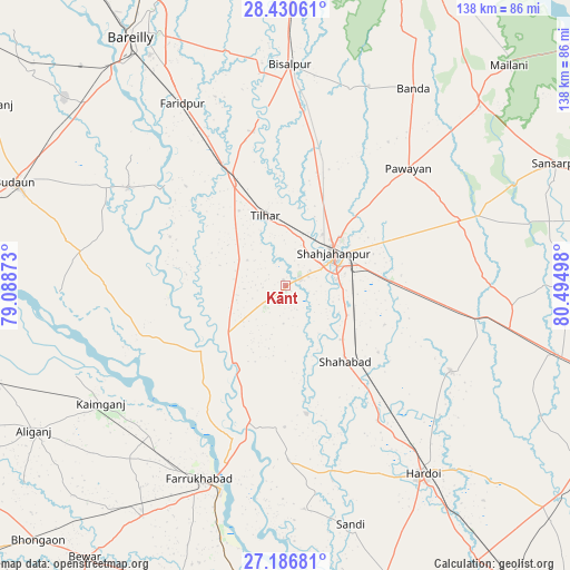
Kānt GPS coordinates[2]
27° 48' 37.764" North, 79° 47' 30.66" East
| Map corner | latitude | longitude |
|---|---|---|
| Upper-left | 28.43061°, | 79.08873° |
| Center: | 27.81049°, | 79.79185° |
| Lower-right: | 27.18681°, | 80.49498° |
| Map W x H: | 138.3×138.3 km | = 85.9×85.9mi |
| max Lat: | 34.9274° ⇑16.4% North |
| Kānt: | 27.81049° |
| min Lat: | ⇓83.6% South 8.09008° |
| min Long | Kānt | max Long |
| 68.82655° | 79.79185° | 96.81° |
| W 66.3%⇐ | ⇒33.7% E |
Elevation
Elevation of Kānt is 155 m = 509 ft, and this is 140.6 m = 461 ft below average elevation for this country.
| Max E: |
3681 m = 12077 ft | 58.6% |
| Avg. | 295.6 m = 970 ft | |
| Kānt | 155 m = 509 ft | |
Min E: |
1 m = 3 ft | 41.4% |
See also: India elevation on elevation.city.
Geographical zone
Kānt is located in North temperate zone (between Tropic of Cancer and the Arctic Circle). Distance of this Northern Tropic circle is 486.3 km =302.2 mi to South.| Distance of | km | miles | from Kānt |
|---|---|---|---|
| North Pole | 6914.8 | 4296.7 | to North |
| Arctic Circle | 4308.9 | 2677.4 | to North |
| Tropic Cancer | 486.3 | 302.2 | to South |
| Equator | 3092.2 | 1921.4 | to South |


Nearby cities:
15 places around Kānt: (largest is in red/bold)
• Allāhganj
31.2 km =19.4 mi,  199°
199°
• Bilsanda
50.6 km =31.4 mi,  18°
18°
• Dātāganj
44.6 km =27.7 mi,  302°
302°
• Farrukhābād
51.1 km =31.8 mi, 204°
• Farīdpur
50.8 km =31.6 mi,  331°
331°
• Fatehgarh
52.1 km =32.4 mi, 197°
• Jalālābād
16.4 km =10.2 mi,  235°
235°
• Khudāganj
38.1 km =23.7 mi,  348°
348°
• Mīrānpur Katra
27.2 km =16.9 mi, 333°
• Pawāyan
41.8 km =26 mi,  47°
47°
• Pihānī
45.7 km =28.4 mi,  117°
117°
• Shamsābād
46.2 km =28.7 mi,  228°
228°
• Shāhjānpur
14 km =8.7 mi,  55°
55°
• Shāhābād
23.7 km =14.7 mi,  141°
141°
• Tilhar
17.7 km =11 mi,  342°
342°
Sources, notices
• [Note1] Compared only with cities in India existing in our database
• [Src1] Map data: © OpenStreetMap contributors (CC-BY-SA)
• [Src2] Other city data from geonames.org with taken over terms of usage.
• [Src3] Geographical zone / Annual Mean Temperature by Robert A. Rohde @ Wikipedia
