Maholi geodata
Maholi (Uttar Pradesh) is a populated place; located in India in Asia/Kolkata (GMT+5.5) time zone. With population of 19,343 people, there are 2094 cities with bigger population in this country. Compared to other cities in India, 82.9% of cities are located further ↓South; 70.8% of cities are located further ←West and 59.5% of cities have higher elevation than Maholi. Note1


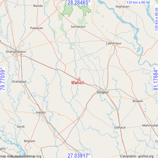
Maholi GPS coordinates[2]
27° 39' 49.248" North, 80° 28' 25.356" East
| Map corner | latitude | longitude |
|---|---|---|
| Upper-left | 28.28465°, | 79.77059° |
| Center: | 27.66368°, | 80.47371° |
| Lower-right: | 27.03917°, | 81.17684° |
| Map W x H: | 138.5×138.5 km | = 86.1×86.1mi |
| max Lat: | 34.9274° ⇑17.1% North |
| Maholi: | 27.66368° |
| min Lat: | ⇓82.9% South 8.09008° |
| min Long | Maholi | max Long |
| 68.82655° | 80.47371° | 96.81° |
| W 70.8%⇐ | ⇒29.2% E |
Elevation
Elevation of Maholi is 151 m = 495 ft, and this is 144.6 m = 474 ft below average elevation for this country.
| Max E: |
3681 m = 12077 ft | 59.5% |
| Avg. | 295.6 m = 970 ft | |
| Maholi | 151 m = 495 ft | |
Min E: |
1 m = 3 ft | 40.5% |
See also: India elevation on elevation.city.
Geographical zone
Maholi is located in North temperate zone (between Tropic of Cancer and the Arctic Circle). Distance of this Northern Tropic circle is 470 km =292 mi to South.| Distance of | km | miles | from Maholi |
|---|---|---|---|
| North Pole | 6931.1 | 4306.8 | to North |
| Arctic Circle | 4325.3 | 2687.6 | to North |
| Tropic Cancer | 470 | 292 | to South |
| Equator | 3075.9 | 1911.3 | to South |


Nearby cities:
15 places around Maholi: (largest is in red/bold)
• Benīganj
41.3 km =25.7 mi,  184°
184°
• Biswān
54.8 km =34.1 mi,  109°
109°
• Gola Gokarannāth
46.1 km =28.6 mi,  359°
359°
• Gopāmau
23.5 km =14.6 mi,  232°
232°
• Hardoī
45.1 km =28 mi, 228°
• Khairābād
31.6 km =19.6 mi,  118°
118°
• Kheri
41.5 km =25.8 mi,  50°
50°
• Lakhīmpur
43.6 km =27.1 mi,  43°
43°
• Lāharpur
42.5 km =26.4 mi,  83°
83°
• Misrikh
26.5 km =16.5 mi,  167°
167°
• Pawāyan
57.7 km =35.9 mi,  320°
320°
• Pihānī
27.1 km =16.8 mi,  259°
259°
• Shāhābād
52.6 km =32.7 mi,  267°
267°
• Sidhaulī
55.4 km =34.4 mi,  140°
140°
• Sītāpur
23.5 km =14.6 mi, 118°
Sources, notices
• [Note1] Compared only with cities in India existing in our database
• [Src1] Map data: © OpenStreetMap contributors (CC-BY-SA)
• [Src2] Other city data from geonames.org with taken over terms of usage.
• [Src3] Geographical zone / Annual Mean Temperature by Robert A. Rohde @ Wikipedia
