Hardoī geodata
Hardoī (Uttar Pradesh) is a populated place; located in India in Asia/Kolkata (GMT+5.5) time zone. With population of 122,635 people, there are 357 cities with bigger population in this country. Compared to other cities in India, 81.2% of cities are located further ↓South; 68.8% of cities are located further ←West and 60.4% of cities have higher elevation than Hardoī. Note1


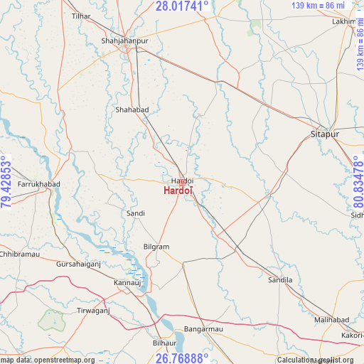
Hardoī GPS coordinates[2]
27° 23' 41.676" North, 80° 7' 53.94" East
| Map corner | latitude | longitude |
|---|---|---|
| Upper-left | 28.01741°, | 79.42853° |
| Center: | 27.39491°, | 80.13165° |
| Lower-right: | 26.76888°, | 80.83478° |
| Map W x H: | 138.8×138.8 km | = 86.2×86.2mi |
| max Lat: | 34.9274° ⇑18.8% North |
| Hardoī: | 27.39491° |
| min Lat: | ⇓81.2% South 8.09008° |
| min Long | Hardoī | max Long |
| 68.82655° | 80.13165° | 96.81° |
| W 68.8%⇐ | ⇒31.2% E |
Elevation
Elevation of Hardoī is 146 m = 479 ft, and this is 149.6 m = 491 ft below average elevation for this country.
| Max E: |
3681 m = 12077 ft | 60.4% |
| Avg. | 295.6 m = 970 ft | |
| Hardoī | 146 m = 479 ft | |
Min E: |
1 m = 3 ft | 39.6% |
See also: Hardoī elevation on elevation.city.
Geographical zone
Hardoī is located in North temperate zone (between Tropic of Cancer and the Arctic Circle). Distance of this Northern Tropic circle is 440.1 km =273.5 mi to South.| Distance of | km | miles | from Hardoī |
|---|---|---|---|
| North Pole | 6961 | 4325.4 | to North |
| Arctic Circle | 4355.1 | 2706.1 | to North |
| Tropic Cancer | 440.1 | 273.5 | to South |
| Equator | 3046 | 1892.7 | to South |


Nearby cities:
15 places around Hardoī: (largest is in red/bold)
• Allāhganj
46.9 km =29.1 mi,  290°
290°
• Benīganj
32.8 km =20.4 mi,  110°
110°
• Bilgrām
26.4 km =16.4 mi,  201°
201°
• Fatehgarh
49.5 km =30.8 mi,  266°
266°
• Ganj Murādābād
48.9 km =30.4 mi,  173°
173°
• Gopāmau
21.7 km =13.5 mi,  44°
44°
• Gursahāiganj
50.3 km =31.3 mi,  231°
231°
• Kamalganj
51.6 km =32.1 mi,  253°
253°
• Kannauj
43.2 km =26.8 mi,  209°
209°
• Maholi
45.1 km =28 mi,  48°
48°
• Misrikh
39.7 km =24.7 mi,  84°
84°
• Mādhoganj
30.8 km =19.1 mi,  178°
178°
• Pihānī
26 km =16.2 mi,  15°
15°
• Shāhābād
33.4 km =20.8 mi,  325°
325°
• Sāndi
21.3 km =13.2 mi,  236°
236°
Sources, notices
• [Note1] Compared only with cities in India existing in our database
• [Src1] Map data: © OpenStreetMap contributors (CC-BY-SA)
• [Src2] Other city data from geonames.org with taken over terms of usage.
• [Src3] Geographical zone / Annual Mean Temperature by Robert A. Rohde @ Wikipedia
