Misrikh geodata
Misrikh (Uttar Pradesh) is a populated place; located in India in Asia/Kolkata (GMT+5.5) time zone. With population of 15,007 people, there are 2462 cities with bigger population in this country. Compared to other cities in India, 81.4% of cities are located further ↓South; 71.1% of cities are located further ←West and 61.1% of cities have higher elevation than Misrikh. Note1


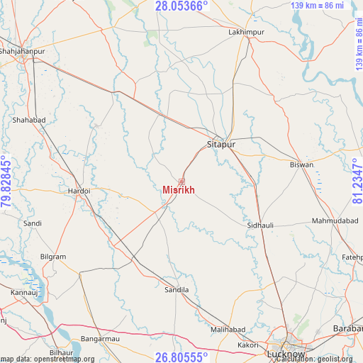
Misrikh GPS coordinates[2]
27° 25' 52.932" North, 80° 31' 53.652" East
| Map corner | latitude | longitude |
|---|---|---|
| Upper-left | 28.05366°, | 79.82845° |
| Center: | 27.43137°, | 80.53157° |
| Lower-right: | 26.80555°, | 81.2347° |
| Map W x H: | 138.8×138.8 km | = 86.2×86.2mi |
| max Lat: | 34.9274° ⇑18.6% North |
| Misrikh: | 27.43137° |
| min Lat: | ⇓81.4% South 8.09008° |
| min Long | Misrikh | max Long |
| 68.82655° | 80.53157° | 96.81° |
| W 71.1%⇐ | ⇒28.9% E |
Elevation
Elevation of Misrikh is 142 m = 466 ft, and this is 153.6 m = 504 ft below average elevation for this country.
| Max E: |
3681 m = 12077 ft | 61.1% |
| Avg. | 295.6 m = 970 ft | |
| Misrikh | 142 m = 466 ft | |
Min E: |
1 m = 3 ft | 38.9% |
See also: India elevation on elevation.city.
Geographical zone
Misrikh is located in North temperate zone (between Tropic of Cancer and the Arctic Circle). Distance of this Northern Tropic circle is 444.2 km =276 mi to South.| Distance of | km | miles | from Misrikh |
|---|---|---|---|
| North Pole | 6957 | 4322.9 | to North |
| Arctic Circle | 4351.1 | 2703.6 | to North |
| Tropic Cancer | 444.2 | 276 | to South |
| Equator | 3050.1 | 1895.2 | to South |


Nearby cities:
15 places around Misrikh: (largest is in red/bold)
• Aurās
57.6 km =35.8 mi,  182°
182°
• Benīganj
17.7 km =11 mi,  209°
209°
• Bilgrām
57 km =35.4 mi,  240°
240°
• Biswān
46.4 km =28.8 mi,  81°
81°
• Gopāmau
26.9 km =16.7 mi,  295°
295°
• Hardoī
39.7 km =24.7 mi,  264°
264°
• Itaunja
52.9 km =32.9 mi,  136°
136°
• Khairābād
24.4 km =15.2 mi,  64°
64°
• Lāharpur
47.8 km =29.7 mi,  49°
49°
• Maholi
26.5 km =16.5 mi,  347°
347°
• Mādhoganj
52 km =32.3 mi,  227°
227°
• Pihānī
38.6 km =24 mi, 302°
• Sandīla
40.2 km =25 mi, 182°
• Sidhaulī
34.2 km =21.3 mi,  119°
119°
• Sītāpur
20.8 km =12.9 mi, 45°
Sources, notices
• [Note1] Compared only with cities in India existing in our database
• [Src1] Map data: © OpenStreetMap contributors (CC-BY-SA)
• [Src2] Other city data from geonames.org with taken over terms of usage.
• [Src3] Geographical zone / Annual Mean Temperature by Robert A. Rohde @ Wikipedia
