Pawāyan geodata
Pawāyan (Uttar Pradesh) is a populated place; located in India in Asia/Kolkata (GMT+5.5) time zone. With population of 25,708 people, there are 1656 cities with bigger population in this country. Compared to other cities in India, 84.7% of cities are located further ↓South; 68.5% of cities are located further ←West and 56.4% of cities have higher elevation than Pawāyan. Note1


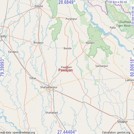
Pawāyan GPS coordinates[2]
28° 3' 58.536" North, 80° 6' 10.98" East
| Map corner | latitude | longitude |
|---|---|---|
| Upper-left | 28.6849°, | 79.39993° |
| Center: | 28.06626°, | 80.10305° |
| Lower-right: | 27.44404°, | 80.80618° |
| Map W x H: | 138×138 km | = 85.7×85.7mi |
| max Lat: | 34.9274° ⇑15.3% North |
| Pawāyan: | 28.06626° |
| min Lat: | ⇓84.7% South 8.09008° |
| min Long | Pawāyan | max Long |
| 68.82655° | 80.10305° | 96.81° |
| W 68.5%⇐ | ⇒31.5% E |
Elevation
Elevation of Pawāyan is 168 m = 551 ft, and this is 127.6 m = 419 ft below average elevation for this country.
| Max E: |
3681 m = 12077 ft | 56.4% |
| Avg. | 295.6 m = 970 ft | |
| Pawāyan | 168 m = 551 ft | |
Min E: |
1 m = 3 ft | 43.6% |
See also: India elevation on elevation.city.
Geographical zone
Pawāyan is located in North temperate zone (between Tropic of Cancer and the Arctic Circle). Distance of this Northern Tropic circle is 514.8 km =319.9 mi to South.| Distance of | km | miles | from Pawāyan |
|---|---|---|---|
| North Pole | 6886.4 | 4279 | to North |
| Arctic Circle | 4280.5 | 2659.8 | to North |
| Tropic Cancer | 514.8 | 319.9 | to South |
| Equator | 3120.7 | 1939.1 | to South |


Nearby cities:
15 places around Pawāyan: (largest is in red/bold)
• Barkhera Kalān
51.8 km =32.2 mi,  325°
325°
• Bilsanda
24.7 km =15.3 mi,  322°
322°
• Bīsalpur
38.6 km =24 mi,  310°
310°
• Gola Gokarannāth
36.1 km =22.4 mi,  87°
87°
• Khudāganj
39.1 km =24.3 mi,  283°
283°
• Khūtār
22.4 km =13.9 mi,  47°
47°
• Kānt
41.8 km =26 mi,  227°
227°
• Mailāni
34.4 km =21.4 mi,  43°
43°
• Mohanpur
25 km =15.5 mi,  33°
33°
• Mīrānpur Katra
42.9 km =26.7 mi,  264°
264°
• Pihānī
50.6 km =31.4 mi,  168°
168°
• Pūranpur
49.9 km =31 mi,  5°
5°
• Shāhjānpur
28 km =17.4 mi,  222°
222°
• Shāhābād
49.7 km =30.9 mi,  198°
198°
• Tilhar
37.6 km =23.4 mi,  252°
252°
Sources, notices
• [Note1] Compared only with cities in India existing in our database
• [Src1] Map data: © OpenStreetMap contributors (CC-BY-SA)
• [Src2] Other city data from geonames.org with taken over terms of usage.
• [Src3] Geographical zone / Annual Mean Temperature by Robert A. Rohde @ Wikipedia
