Garhshankar geodata
Garhshankar (Punjab) is a populated place; located in India in Asia/Kolkata (GMT+5.5) time zone. With population of 16,470 people, there are 2331 cities with bigger population in this country. Compared to other cities in India, 96.4% of cities are located further ↓South; 72.2% of cities are located further →East and 63.2% of cities have lower elevation than Garhshankar. Note1


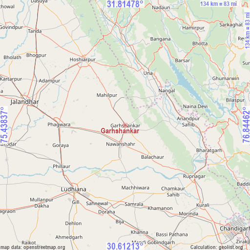
Garhshankar GPS coordinates[2]
31° 12' 55.332" North, 76° 8' 29.364" East
| Map corner | latitude | longitude |
|---|---|---|
| Upper-left | 31.81478°, | 75.43837° |
| Center: | 31.21537°, | 76.14149° |
| Lower-right: | 30.61213°, | 76.84462° |
| Map W x H: | 133.7×133.7 km | = 83.1×83.1mi |
| max Lat: | 34.9274° ⇑3.6% North |
| Garhshankar: | 31.21537° |
| min Lat: | ⇓96.4% South 8.09008° |
| min Long | Garhshankar | max Long |
| 68.82655° | 76.14149° | 96.81° |
| W 27.8%⇐ | ⇒72.2% E |
Elevation
Elevation of Garhshankar is 273 m = 896 ft, and this is 22.6 m = 74 ft below average elevation for this country.
| Max E: |
3681 m = 12077 ft | 36.8% |
| Avg. | 295.6 m = 970 ft | |
| Garhshankar | 273 m = 896 ft | |
Min E: |
1 m = 3 ft | 63.2% |
See also: India elevation on elevation.city.
Geographical zone
Garhshankar is located in North temperate zone (between Tropic of Cancer and the Arctic Circle). Distance of this Northern Tropic circle is 864.9 km =537.4 mi to South.| Distance of | km | miles | from Garhshankar |
|---|---|---|---|
| North Pole | 6536.2 | 4061.4 | to North |
| Arctic Circle | 3930.4 | 2442.2 | to North |
| Tropic Cancer | 864.9 | 537.4 | to South |
| Equator | 3470.8 | 2156.7 | to South |


Nearby cities:
15 places around Garhshankar: (largest is in red/bold)
• Anandpur
34.4 km =21.4 mi,  85°
85°
• Banga
14.2 km =8.8 mi,  258°
258°
• Bālāchor
23 km =14.3 mi,  138°
138°
• Hoshiārpur
41.9 km =26 mi,  328°
328°
• Ludhiāna
43.5 km =27 mi,  219°
219°
• Māchhīwāra
33.8 km =21 mi,  170°
170°
• Nangal
29.5 km =18.3 mi,  48°
48°
• Nawanshahr
10.4 km =6.5 mi,  193°
193°
• Nūrpur Kalān
33 km =20.5 mi,  99°
99°
• Phagwāra
35 km =21.7 mi,  271°
271°
• Phillaur
39.9 km =24.8 mi,  236°
236°
• Rāhon
18.2 km =11.3 mi, 186°
• Samrāla
42.5 km =26.4 mi, 173°
• Santokhgarh
22.6 km =14 mi, 47°
• Una
30.3 km =18.8 mi,  23°
23°
Sources, notices
• [Note1] Compared only with cities in India existing in our database
• [Src1] Map data: © OpenStreetMap contributors (CC-BY-SA)
• [Src2] Other city data from geonames.org with taken over terms of usage.
• [Src3] Geographical zone / Annual Mean Temperature by Robert A. Rohde @ Wikipedia
