Ferozepore geodata
Ferozepore (Punjab) is a populated place; located in India in Asia/Kolkata (GMT+5.5) time zone. With population of 102,130 people, there are 429 cities with bigger population in this country. Compared to other cities in India, 95.6% of cities are located further ↓South; 85.9% of cities are located further →East and 50.2% of cities have higher elevation than Ferozepore. Note1


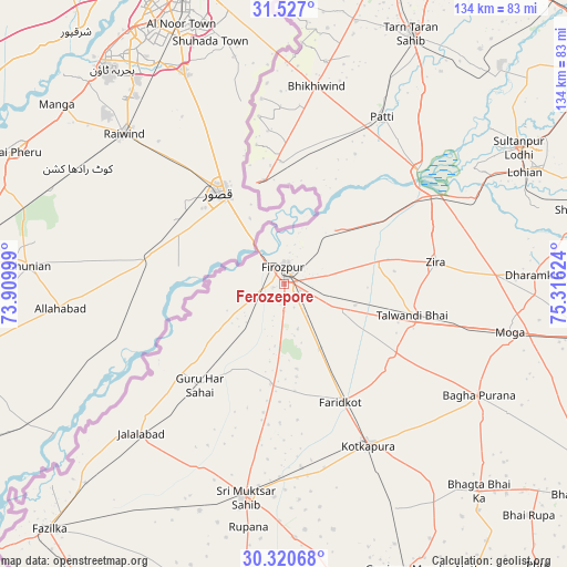
Ferozepore GPS coordinates[2]
30° 55' 32.664" North, 74° 36' 47.196" East
| Map corner | latitude | longitude |
|---|---|---|
| Upper-left | 31.527°, | 73.90999° |
| Center: | 30.92574°, | 74.61311° |
| Lower-right: | 30.32068°, | 75.31624° |
| Map W x H: | 134.1×134.1 km | = 83.3×83.3mi |
| max Lat: | 34.9274° ⇑4.4% North |
| Ferozepore: | 30.92574° |
| min Lat: | ⇓95.6% South 8.09008° |
| min Long | Ferozepore | max Long |
| 68.82655° | 74.61311° | 96.81° |
| W 14.1%⇐ | ⇒85.9% E |
Elevation
Elevation of Ferozepore is 200 m = 656 ft, and this is 95.6 m = 314 ft below average elevation for this country.
| Max E: |
3681 m = 12077 ft | 50.2% |
| Avg. | 295.6 m = 970 ft | |
| Ferozepore | 200 m = 656 ft | |
Min E: |
1 m = 3 ft | 49.8% |
See also: Ferozepore elevation on elevation.city.
Geographical zone
Ferozepore is located in North temperate zone (between Tropic of Cancer and the Arctic Circle). Distance of this Northern Tropic circle is 832.7 km =517.4 mi to South.| Distance of | km | miles | from Ferozepore |
|---|---|---|---|
| North Pole | 6568.4 | 4081.4 | to North |
| Arctic Circle | 3962.6 | 2462.2 | to North |
| Tropic Cancer | 832.7 | 517.4 | to South |
| Equator | 3438.6 | 2136.6 | to South |


Nearby cities:
15 places around Ferozepore: (largest is in red/bold)
• Bāgha Purāna
53.3 km =33.1 mi,  119°
119°
• Farīdkot
31.1 km =19.3 mi,  154°
154°
• Guru Har Sahāi
31.3 km =19.4 mi,  219°
219°
• Jaito
59.1 km =36.7 mi, 153°
• Jalālābād
49.2 km =30.6 mi, 223°
• Khem Karan
24.8 km =15.4 mi,  348°
348°
• Kot Īsa Khān
50.1 km =31.1 mi,  87°
87°
• Kotkapura
43.6 km =27.1 mi, 151°
• Makhu
41.5 km =25.8 mi,  61°
61°
• Moga
54.5 km =33.9 mi,  103°
103°
• Muktsar
51 km =31.7 mi,  190°
190°
• Patti
45.9 km =28.5 mi,  30°
30°
• Sultanpur
64.1 km =39.8 mi, 59°
• Talwandi Bhai
31.2 km =19.4 mi, 104°
• Zira
36.4 km =22.6 mi,  82°
82°
Sources, notices
• [Note1] Compared only with cities in India existing in our database
• [Src1] Map data: © OpenStreetMap contributors (CC-BY-SA)
• [Src2] Other city data from geonames.org with taken over terms of usage.
• [Src3] Geographical zone / Annual Mean Temperature by Robert A. Rohde @ Wikipedia
