Parola geodata
Parola (Maharashtra) is a populated place; located in India in Asia/Kolkata (GMT+5.5) time zone. With population of 37,001 people, there are 1186 cities with bigger population in this country. Compared to other cities in India, 62.1% of cities are located further ↑North; 81.7% of cities are located further →East and 60.7% of cities have lower elevation than Parola. Note1


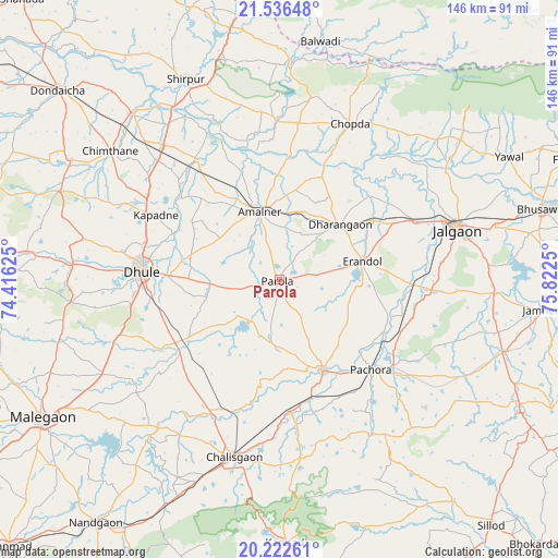
Parola GPS coordinates[2]
20° 52' 51.528" North, 75° 7' 9.732" East
| Map corner | latitude | longitude |
|---|---|---|
| Upper-left | 21.53648°, | 74.41625° |
| Center: | 20.88098°, | 75.11937° |
| Lower-right: | 20.22261°, | 75.8225° |
| Map W x H: | 146.1×146.1 km | = 90.8×90.8mi |
| max Lat: | 34.9274° ⇑62.1% North |
| Parola: | 20.88098° |
| min Lat: | ⇓37.9% South 8.09008° |
| min Long | Parola | max Long |
| 68.82655° | 75.11937° | 96.81° |
| W 18.3%⇐ | ⇒81.7% E |
Elevation
Elevation of Parola is 256 m = 840 ft, and this is 39.6 m = 130 ft below average elevation for this country.
| Max E: |
3681 m = 12077 ft | 39.3% |
| Avg. | 295.6 m = 970 ft | |
| Parola | 256 m = 840 ft | |
Min E: |
1 m = 3 ft | 60.7% |
See also: India elevation on elevation.city.
Geographical zone
Parola is located in North Torrid zone (between Equator and Tropic of Cancer). Distance of this Northern Tropic circle is 284.2 km =176.6 mi to North.| Distance of | km | miles | from Parola |
|---|---|---|---|
| North Pole | 7685.3 | 4775.4 | to North |
| Arctic Circle | 5079.4 | 3156.2 | to North |
| Tropic Cancer | 284.2 | 176.6 | to North |
| Equator | 2321.7 | 1442.6 | to South |


Nearby cities:
15 places around Parola: (largest is in red/bold)
• Amalner
18.7 km =11.6 mi,  340°
340°
• Bhusāval
71.4 km =44.4 mi,  75°
75°
• Chopda
44.7 km =27.8 mi,  24°
24°
• Chālisgaon
48.3 km =30 mi,  192°
192°
• Dharangaon
21.7 km =13.5 mi,  47°
47°
• Dhūlia
35.6 km =22.1 mi,  273°
273°
• Dondaicha
75.5 km =46.9 mi,  310°
310°
• Erandol
22 km =13.7 mi, 78°
• Jalgaon
48.3 km =30 mi,  73°
73°
• Kannad
69.4 km =43.1 mi,  178°
178°
• Mālegaon
71.1 km =44.2 mi,  238°
238°
• Pāchora
34 km =21.1 mi,  134°
134°
• Shirpur
57.6 km =35.8 mi,  334°
334°
• Soygaon
60.7 km =37.7 mi,  121°
121°
• Yāval
68 km =42.3 mi,  62°
62°
Sources, notices
• [Note1] Compared only with cities in India existing in our database
• [Src1] Map data: © OpenStreetMap contributors (CC-BY-SA)
• [Src2] Other city data from geonames.org with taken over terms of usage.
• [Src3] Geographical zone / Annual Mean Temperature by Robert A. Rohde @ Wikipedia
