Kannad geodata
Kannad (Maharashtra) is a populated place; located in India in Asia/Kolkata (GMT+5.5) time zone. With population of 42,056 people, there are 1051 cities with bigger population in this country. Compared to other cities in India, 64.4% of cities are located further ↑North; 81.5% of cities are located further →East and 89.6% of cities have lower elevation than Kannad. Note1


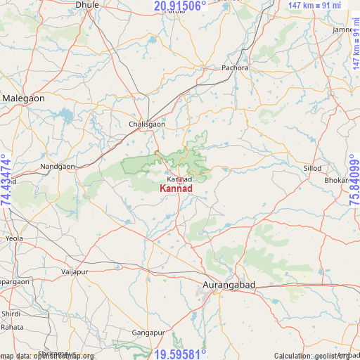
Kannad GPS coordinates[2]
20° 15' 24.624" North, 75° 8' 16.296" East
| Map corner | latitude | longitude |
|---|---|---|
| Upper-left | 20.91506°, | 74.43474° |
| Center: | 20.25684°, | 75.13786° |
| Lower-right: | 19.59581°, | 75.84099° |
| Map W x H: | 146.7×146.7 km | = 91.2×91.2mi |
| max Lat: | 34.9274° ⇑64.4% North |
| Kannad: | 20.25684° |
| min Lat: | ⇓35.6% South 8.09008° |
| min Long | Kannad | max Long |
| 68.82655° | 75.13786° | 96.81° |
| W 18.5%⇐ | ⇒81.5% E |
Elevation
Elevation of Kannad is 629 m = 2064 ft, and this is 333.4 m = 1094 ft above average elevation for this country.
| Max E: |
3681 m = 12077 ft | 10.4% |
| Kannad | 629 m 2064 ft | |
| Avg. | 295.6 m = 970 ft | |
Min E: |
1 m = 3 ft | 89.6% |
See also: Kannad elevation on elevation.city.
Geographical zone
Kannad is located in North Torrid zone (between Equator and Tropic of Cancer). Distance of this Northern Tropic circle is 353.6 km =219.7 mi to North.| Distance of | km | miles | from Kannad |
|---|---|---|---|
| North Pole | 7754.7 | 4818.5 | to North |
| Arctic Circle | 5148.8 | 3199.3 | to North |
| Tropic Cancer | 353.6 | 219.7 | to North |
| Equator | 2252.3 | 1399.5 | to South |


Nearby cities:
15 places around Kannad: (largest is in red/bold)
• Aurangabad
47.3 km =29.4 mi,  153°
153°
• Chālisgaon
25.7 km =16 mi,  330°
330°
• Daulatābād
36.7 km =22.8 mi,  166°
166°
• Ellora
26.1 km =16.2 mi, 174°
• Gangāpur
63.6 km =39.5 mi,  192°
192°
• Khuldābād
28.4 km =17.6 mi, 168°
• Mālegaon
70.8 km =44 mi,  297°
297°
• Nāndgaon
50.7 km =31.5 mi,  276°
276°
• Parola
69.4 km =43.1 mi,  358°
358°
• Pāchora
50.8 km =31.6 mi,  26°
26°
• Pīpri
66.1 km =41.1 mi,  141°
141°
• Sillod
54 km =33.6 mi,  84°
84°
• Soygaon
62.6 km =38.9 mi,  52°
52°
• Vaijāpur
56.4 km =35 mi,  229°
229°
• Yeola
71.8 km =44.6 mi,  250°
250°
Sources, notices
• [Note1] Compared only with cities in India existing in our database
• [Src1] Map data: © OpenStreetMap contributors (CC-BY-SA)
• [Src2] Other city data from geonames.org with taken over terms of usage.
• [Src3] Geographical zone / Annual Mean Temperature by Robert A. Rohde @ Wikipedia
