Mālegaon geodata
Mālegaon (Maharashtra) is a populated place; located in India in Asia/Kolkata (GMT+5.5) time zone. With population of 435,362 people, there are 102 cities with bigger population in this country. Compared to other cities in India, 63.5% of cities are located further ↑North; 86.6% of cities are located further →East and 78.1% of cities have lower elevation than Mālegaon. Note1


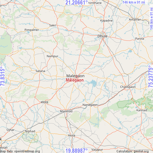
Mālegaon GPS coordinates[2]
20° 32' 58.776" North, 74° 32' 4.632" East
| Map corner | latitude | longitude |
|---|---|---|
| Upper-left | 21.20661°, | 73.8315° |
| Center: | 20.54966°, | 74.53462° |
| Lower-right: | 19.88987°, | 75.23775° |
| Map W x H: | 146.4×146.4 km | = 91×91mi |
| max Lat: | 34.9274° ⇑63.5% North |
| Mālegaon: | 20.54966° |
| min Lat: | ⇓36.5% South 8.09008° |
| min Long | Mālegaon | max Long |
| 68.82655° | 74.53462° | 96.81° |
| W 13.4%⇐ | ⇒86.6% E |
Elevation
Elevation of Mālegaon is 432 m = 1417 ft, and this is 136.4 m = 448 ft above average elevation for this country.
| Max E: |
3681 m = 12077 ft | 21.9% |
| Mālegaon | 432 m 1417 ft | |
| Avg. | 295.6 m = 970 ft | |
Min E: |
1 m = 3 ft | 78.1% |
See also: Mālegaon elevation on elevation.city.
Geographical zone
Mālegaon is located in North Torrid zone (between Equator and Tropic of Cancer). Distance of this Northern Tropic circle is 321 km =199.5 mi to North.| Distance of | km | miles | from Mālegaon |
|---|---|---|---|
| North Pole | 7722.2 | 4798.4 | to North |
| Arctic Circle | 5116.3 | 3179.1 | to North |
| Tropic Cancer | 321 | 199.5 | to North |
| Equator | 2284.9 | 1419.8 | to South |


Nearby cities:
15 places around Mālegaon: (largest is in red/bold)
• Amalner
77.1 km =47.9 mi,  44°
44°
• Chālisgaon
51.2 km =31.8 mi,  101°
101°
• Chāndor
38.8 km =24.1 mi,  231°
231°
• Dhūlia
46.5 km =28.9 mi,  32°
32°
• Dondaicha
86.1 km =53.5 mi,  2°
2°
• Kannad
70.8 km =44 mi,  117°
117°
• Kopargaon
74.4 km =46.2 mi,  184°
184°
• Lāsalgaon
54.7 km =34 mi,  214°
214°
• Manmād
34.5 km =21.4 mi,  197°
197°
• Nāndgaon
29.8 km =18.5 mi,  155°
155°
• Ozar
81 km =50.3 mi, 231°
• Parola
71.1 km =44.2 mi,  58°
58°
• Satānā
34.9 km =21.7 mi,  278°
278°
• Vaijāpur
72.1 km =44.8 mi, 163°
• Yeola
56.6 km =35.2 mi, 184°
Sources, notices
• [Note1] Compared only with cities in India existing in our database
• [Src1] Map data: © OpenStreetMap contributors (CC-BY-SA)
• [Src2] Other city data from geonames.org with taken over terms of usage.
• [Src3] Geographical zone / Annual Mean Temperature by Robert A. Rohde @ Wikipedia
