Chālisgaon geodata
Chālisgaon (Maharashtra) is a populated place; located in India in Asia/Kolkata (GMT+5.5) time zone. With population of 96,381 people, there are 461 cities with bigger population in this country. Compared to other cities in India, 63.8% of cities are located further ↑North; 82.6% of cities are located further →East and 71.7% of cities have lower elevation than Chālisgaon. Note1


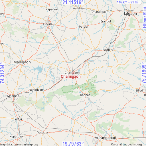
Chālisgaon GPS coordinates[2]
20° 27' 28.116" North, 75° 0' 57.456" East
| Map corner | latitude | longitude |
|---|---|---|
| Upper-left | 21.11516°, | 74.31284° |
| Center: | 20.45781°, | 75.01596° |
| Lower-right: | 19.79763°, | 75.71909° |
| Map W x H: | 146.5×146.5 km | = 91×91mi |
| max Lat: | 34.9274° ⇑63.8% North |
| Chālisgaon: | 20.45781° |
| min Lat: | ⇓36.2% South 8.09008° |
| min Long | Chālisgaon | max Long |
| 68.82655° | 75.01596° | 96.81° |
| W 17.4%⇐ | ⇒82.6% E |
Elevation
Elevation of Chālisgaon is 346 m = 1135 ft, and this is 50.4 m = 165 ft above average elevation for this country.
| Max E: |
3681 m = 12077 ft | 28.3% |
| Chālisgaon | 346 m 1135 ft | |
| Avg. | 295.6 m = 970 ft | |
Min E: |
1 m = 3 ft | 71.7% |
See also: Chālisgaon elevation on elevation.city.
Geographical zone
Chālisgaon is located in North Torrid zone (between Equator and Tropic of Cancer). Distance of this Northern Tropic circle is 331.2 km =205.8 mi to North.| Distance of | km | miles | from Chālisgaon |
|---|---|---|---|
| North Pole | 7732.4 | 4804.7 | to North |
| Arctic Circle | 5126.5 | 3185.5 | to North |
| Tropic Cancer | 331.2 | 205.8 | to North |
| Equator | 2274.7 | 1413.4 | to South |


Nearby cities:
15 places around Chālisgaon: (largest is in red/bold)
• Amalner
64.9 km =40.3 mi,  3°
3°
• Daulatābād
61.8 km =38.4 mi,  159°
159°
• Dharangaon
67.2 km =41.8 mi,  23°
23°
• Dhūlia
55.2 km =34.3 mi,  333°
333°
• Ellora
50.7 km =31.5 mi, 162°
• Erandol
60.9 km =37.8 mi,  32°
32°
• Kannad
25.7 km =16 mi,  150°
150°
• Khuldābād
53.4 km =33.2 mi, 159°
• Manmād
64.4 km =40 mi,  249°
249°
• Mālegaon
51.2 km =31.8 mi,  281°
281°
• Nāndgaon
41.2 km =25.6 mi, 245°
• Parola
48.3 km =30 mi,  12°
12°
• Pāchora
42.1 km =26.2 mi,  56°
56°
• Soygaon
64.5 km =40.1 mi,  76°
76°
• Vaijāpur
66.3 km =41.2 mi,  207°
207°
Sources, notices
• [Note1] Compared only with cities in India existing in our database
• [Src1] Map data: © OpenStreetMap contributors (CC-BY-SA)
• [Src2] Other city data from geonames.org with taken over terms of usage.
• [Src3] Geographical zone / Annual Mean Temperature by Robert A. Rohde @ Wikipedia
