Dhūlia geodata
Dhūlia (Maharashtra) is a seat of a second-order administrative division; located in India in Asia/Kolkata (GMT+5.5) time zone. With population of 366,980 people, there are 119 cities with bigger population in this country. Compared to other cities in India, 62% of cities are located further ↑North; 84.5% of cities are located further →East and 62.3% of cities have lower elevation than Dhūlia. Note1


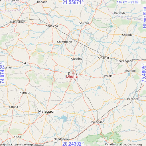
Dhūlia GPS coordinates[2]
20° 54' 4.68" North, 74° 46' 38.532" East
| Map corner | latitude | longitude |
|---|---|---|
| Upper-left | 21.55671°, | 74.07425° |
| Center: | 20.9013°, | 74.77737° |
| Lower-right: | 20.24302°, | 75.4805° |
| Map W x H: | 146.1×146.1 km | = 90.8×90.8mi |
| max Lat: | 34.9274° ⇑62% North |
| Dhūlia: | 20.9013° |
| min Lat: | ⇓38% South 8.09008° |
| min Long | Dhūlia | max Long |
| 68.82655° | 74.77737° | 96.81° |
| W 15.5%⇐ | ⇒84.5% E |
Elevation
Elevation of Dhūlia is 266 m = 873 ft, and this is 29.6 m = 97 ft below average elevation for this country.
| Max E: |
3681 m = 12077 ft | 37.7% |
| Avg. | 295.6 m = 970 ft | |
| Dhūlia | 266 m = 873 ft | |
Min E: |
1 m = 3 ft | 62.3% |
See also: Dhūlia elevation on elevation.city.
Geographical zone
Dhūlia is located in North Torrid zone (between Equator and Tropic of Cancer). Distance of this Northern Tropic circle is 281.9 km =175.2 mi to North.| Distance of | km | miles | from Dhūlia |
|---|---|---|---|
| North Pole | 7683.1 | 4774.1 | to North |
| Arctic Circle | 5077.2 | 3154.8 | to North |
| Tropic Cancer | 281.9 | 175.2 | to North |
| Equator | 2324 | 1444.1 | to South |


Nearby cities:
15 places around Dhūlia: (largest is in red/bold)
• Amalner
33 km =20.5 mi,  62°
62°
• Chopda
66.3 km =41.2 mi,  54°
54°
• Chālisgaon
55.2 km =34.3 mi,  153°
153°
• Dharangaon
53 km =32.9 mi,  76°
76°
• Dondaicha
51.7 km =32.1 mi,  335°
335°
• Erandol
57.1 km =35.5 mi,  87°
87°
• Manmād
80.3 km =49.9 mi,  206°
206°
• Mālegaon
46.5 km =28.9 mi, 212°
• Nandurbar
76 km =47.2 mi,  312°
312°
• Nāndgaon
67.3 km =41.8 mi,  190°
190°
• Parola
35.6 km =22.1 mi, 93°
• Pāchora
65.3 km =40.6 mi,  113°
113°
• Satānā
68.8 km =42.8 mi,  240°
240°
• Shirpur
50.8 km =31.6 mi,  12°
12°
• Shāhāda
78.3 km =48.7 mi, 336°
Sources, notices
• [Note1] Compared only with cities in India existing in our database
• [Src1] Map data: © OpenStreetMap contributors (CC-BY-SA)
• [Src2] Other city data from geonames.org with taken over terms of usage.
• [Src3] Geographical zone / Annual Mean Temperature by Robert A. Rohde @ Wikipedia
