Soygaon geodata
Soygaon (Maharashtra) is a populated place; located in India in Asia/Kolkata (GMT+5.5) time zone. With population of 23,320 people, there are 1816 cities with bigger population in this country. Compared to other cities in India, 63.4% of cities are located further ↑North; 77.4% of cities are located further →East and 74.3% of cities have lower elevation than Soygaon. Note1


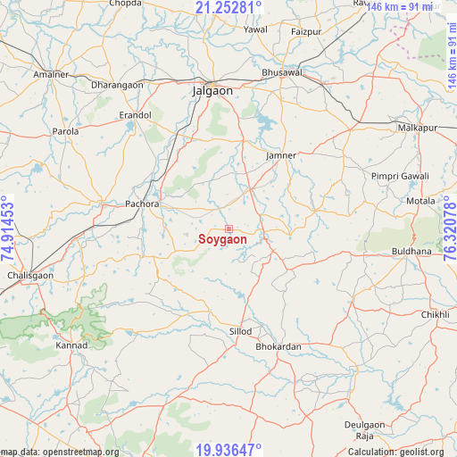
Soygaon GPS coordinates[2]
20° 35' 45.816" North, 75° 37' 3.54" East
| Map corner | latitude | longitude |
|---|---|---|
| Upper-left | 21.25281°, | 74.91453° |
| Center: | 20.59606°, | 75.61765° |
| Lower-right: | 19.93647°, | 76.32078° |
| Map W x H: | 146.4×146.4 km | = 91×91mi |
| max Lat: | 34.9274° ⇑63.4% North |
| Soygaon: | 20.59606° |
| min Lat: | ⇓36.6% South 8.09008° |
| min Long | Soygaon | max Long |
| 68.82655° | 75.61765° | 96.81° |
| W 22.6%⇐ | ⇒77.4% E |
Elevation
Elevation of Soygaon is 377 m = 1237 ft, and this is 81.4 m = 267 ft above average elevation for this country.
| Max E: |
3681 m = 12077 ft | 25.7% |
| Soygaon | 377 m 1237 ft | |
| Avg. | 295.6 m = 970 ft | |
Min E: |
1 m = 3 ft | 74.3% |
See also: India elevation on elevation.city.
Geographical zone
Soygaon is located in North Torrid zone (between Equator and Tropic of Cancer). Distance of this Northern Tropic circle is 315.9 km =196.3 mi to North.| Distance of | km | miles | from Soygaon |
|---|---|---|---|
| North Pole | 7717 | 4795.1 | to North |
| Arctic Circle | 5111.1 | 3175.9 | to North |
| Tropic Cancer | 315.9 | 196.3 | to North |
| Equator | 2290.1 | 1423 | to South |


Nearby cities:
15 places around Soygaon: (largest is in red/bold)
• Bhusāval
52.7 km =32.7 mi,  19°
19°
• Buldāna
59.5 km =37 mi,  97°
97°
• Chālisgaon
64.5 km =40.1 mi,  256°
256°
• Dharangaon
58.4 km =36.3 mi,  322°
322°
• Erandol
47.2 km =29.3 mi, 320°
• Faizpur
68.4 km =42.5 mi, 21°
• Jalgaon
45.6 km =28.3 mi,  353°
353°
• Kannad
62.6 km =38.9 mi,  232°
232°
• Malkāpur
68.5 km =42.6 mi,  61°
61°
• Parola
60.7 km =37.7 mi,  301°
301°
• Pāchora
28.6 km =17.8 mi,  286°
286°
• Sillod
32.8 km =20.4 mi,  173°
173°
• Sāvda
67.8 km =42.1 mi, 24°
• Varangaon
55.9 km =34.7 mi,  32°
32°
• Yāval
64.1 km =39.8 mi,  7°
7°
Sources, notices
• [Note1] Compared only with cities in India existing in our database
• [Src1] Map data: © OpenStreetMap contributors (CC-BY-SA)
• [Src2] Other city data from geonames.org with taken over terms of usage.
• [Src3] Geographical zone / Annual Mean Temperature by Robert A. Rohde @ Wikipedia
