Shāhpur geodata
Shāhpur (Madhya Pradesh) is a populated place; located in India in Asia/Kolkata (GMT+5.5) time zone. With population of 19,370 people, there are 2092 cities with bigger population in this country. Compared to other cities in India, 60.5% of cities are located further ↑North; 71.3% of cities are located further →East and 60.3% of cities have lower elevation than Shāhpur. Note1


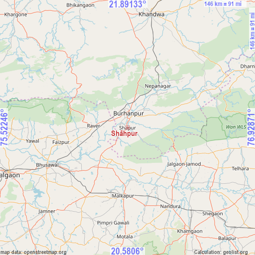
Shāhpur GPS coordinates[2]
21° 14' 14.712" North, 76° 13' 32.088" East
| Map corner | latitude | longitude |
|---|---|---|
| Upper-left | 21.89133°, | 75.52246° |
| Center: | 21.23742°, | 76.22558° |
| Lower-right: | 20.5806°, | 76.92871° |
| Map W x H: | 145.7×145.7 km | = 90.5×90.5mi |
| max Lat: | 34.9274° ⇑60.5% North |
| Shāhpur: | 21.23742° |
| min Lat: | ⇓39.5% South 8.09008° |
| min Long | Shāhpur | max Long |
| 68.82655° | 76.22558° | 96.81° |
| W 28.7%⇐ | ⇒71.3% E |
Elevation
Elevation of Shāhpur is 253 m = 830 ft, and this is 42.6 m = 140 ft below average elevation for this country.
| Max E: |
3681 m = 12077 ft | 39.7% |
| Avg. | 295.6 m = 970 ft | |
| Shāhpur | 253 m = 830 ft | |
Min E: |
1 m = 3 ft | 60.3% |
See also: India elevation on elevation.city.
Geographical zone
Shāhpur is located in North Torrid zone (between Equator and Tropic of Cancer). Distance of this Northern Tropic circle is 244.5 km =151.9 mi to North.| Distance of | km | miles | from Shāhpur |
|---|---|---|---|
| North Pole | 7645.7 | 4750.8 | to North |
| Arctic Circle | 5039.8 | 3131.6 | to North |
| Tropic Cancer | 244.5 | 151.9 | to North |
| Equator | 2361.4 | 1467.3 | to South |


Nearby cities:
15 places around Shāhpur: (largest is in red/bold)
• Bhusāval
50.5 km =31.4 mi,  244°
244°
• Burhānpur
7.9 km =4.9 mi,  3°
3°
• Faizpur
38.7 km =24 mi,  258°
258°
• Jalgaon Jamod
38.1 km =23.7 mi,  122°
122°
• Khandwa
66.5 km =41.3 mi,  11°
11°
• Khāmgaon
68.8 km =42.8 mi,  148°
148°
• Malkāpur
39.2 km =24.4 mi,  183°
183°
• Nepānagar
29.7 km =18.5 mi,  35°
35°
• Nāndūra Buzurg
51 km =31.7 mi, 151°
• Pandhāna
51.2 km =31.8 mi,  359°
359°
• Rāver
19.8 km =12.3 mi,  273°
273°
• Sāvda
36.2 km =22.5 mi,  254°
254°
• Telhāra
67.8 km =42.1 mi,  110°
110°
• Varangaon
40.8 km =25.4 mi,  233°
233°
• Yāval
55.3 km =34.4 mi, 261°
Sources, notices
• [Note1] Compared only with cities in India existing in our database
• [Src1] Map data: © OpenStreetMap contributors (CC-BY-SA)
• [Src2] Other city data from geonames.org with taken over terms of usage.
• [Src3] Geographical zone / Annual Mean Temperature by Robert A. Rohde @ Wikipedia
