Bellūru geodata
Bellūru (Karnataka) is a populated place; located in India in Asia/Kolkata (GMT+5.5) time zone. With population of 7,626 people, there are 3154 cities with bigger population in this country. Compared to other cities in India, 86.4% of cities are located further ↑North; 65.9% of cities are located further →East and 94% of cities have lower elevation than Bellūru. Note1


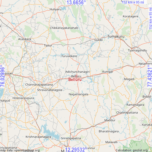
Bellūru GPS coordinates[2]
12° 58' 53.04" North, 76° 43' 59.088" East
| Map corner | latitude | longitude |
|---|---|---|
| Upper-left | 13.6656°, | 76.02996° |
| Center: | 12.9814°, | 76.73308° |
| Lower-right: | 12.29532°, | 77.43621° |
| Map W x H: | 152.4×152.4 km | = 94.7×94.7mi |
| max Lat: | 34.9274° ⇑86.4% North |
| Bellūru: | 12.9814° |
| min Lat: | ⇓13.6% South 8.09008° |
| min Long | Bellūru | max Long |
| 68.82655° | 76.73308° | 96.81° |
| W 34.1%⇐ | ⇒65.9% E |
Elevation
Elevation of Bellūru is 797 m = 2615 ft, and this is 501.4 m = 1645 ft above average elevation for this country.
| Max E: |
3681 m = 12077 ft | 6% |
| Bellūru | 797 m 2615 ft | |
| Avg. | 295.6 m = 970 ft | |
Min E: |
1 m = 3 ft | 94% |
See also: India elevation on elevation.city.
Geographical zone
Bellūru is located in North Torrid zone (between Equator and Tropic of Cancer). Distance of this Northern Tropic circle is 1162.5 km =722.3 mi to North.| Distance of | km | miles | from Bellūru |
|---|---|---|---|
| North Pole | 8563.7 | 5321.2 | to North |
| Arctic Circle | 5957.8 | 3702 | to North |
| Tropic Cancer | 1162.5 | 722.3 | to North |
| Equator | 1443.4 | 896.9 | to South |


Nearby cities:
15 places around Bellūru: (largest is in red/bold)
• Channarāyapatna
38.3 km =23.8 mi,  257°
257°
• Chiknāyakanhalli
49.8 km =30.9 mi,  345°
345°
• French Rocks
53.8 km =33.4 mi,  186°
186°
• Gubbi
43.1 km =26.8 mi,  31°
31°
• Krishnarājpet
44 km =27.3 mi,  217°
217°
• Kunigal
32 km =19.9 mi,  81°
81°
• Maddūr
55.6 km =34.5 mi,  142°
142°
• Mandya
54.1 km =33.6 mi,  160°
160°
• Melukote
36.6 km =22.7 mi, 194°
• Māgadi
53.2 km =33.1 mi,  92°
92°
• Nāgamangala
18.2 km =11.3 mi,  172°
172°
• Srāvana Belgola
29.8 km =18.5 mi,  242°
242°
• Tiptūr
41.2 km =25.6 mi,  317°
317°
• Tumkūr
56.6 km =35.2 mi,  44°
44°
• Turuvekere
21.5 km =13.4 mi,  340°
340°
Sources, notices
• [Note1] Compared only with cities in India existing in our database
• [Src1] Map data: © OpenStreetMap contributors (CC-BY-SA)
• [Src2] Other city data from geonames.org with taken over terms of usage.
• [Src3] Geographical zone / Annual Mean Temperature by Robert A. Rohde @ Wikipedia
