Roha geodata
Roha (Gujarat) is a populated place; located in India in Asia/Kolkata (GMT+5.5) time zone. With population of 8,664 people, there are 3065 cities with bigger population in this country. Compared to other cities in India, 52.9% of cities are located further ↓South; 99.9% of cities are located further →East and 55% of cities have higher elevation than Roha. Note1


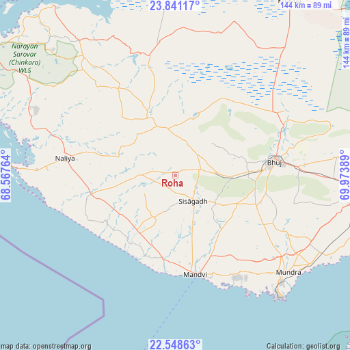
Roha GPS coordinates[2]
23° 11' 47.256" North, 69° 16' 14.736" East
| Map corner | latitude | longitude |
|---|---|---|
| Upper-left | 23.84117°, | 68.56764° |
| Center: | 23.19646°, | 69.27076° |
| Lower-right: | 22.54863°, | 69.97389° |
| Map W x H: | 143.7×143.7 km | = 89.3×89.3mi |
| max Lat: | 34.9274° ⇑47.1% North |
| Roha: | 23.19646° |
| min Lat: | ⇓52.9% South 8.09008° |
| min Long | Roha | max Long |
| 68.82655° | 69.27076° | 96.81° |
| W 0.1%⇐ | ⇒99.9% E |
Elevation
Elevation of Roha is 175 m = 574 ft, and this is 120.6 m = 396 ft below average elevation for this country.
| Max E: |
3681 m = 12077 ft | 55% |
| Avg. | 295.6 m = 970 ft | |
| Roha | 175 m = 574 ft | |
Min E: |
1 m = 3 ft | 45% |
See also: India elevation on elevation.city.
Geographical zone
Roha is located in North Torrid zone (between Equator and Tropic of Cancer). Distance of this Northern Tropic circle is 26.7 km =16.6 mi to North.| Distance of | km | miles | from Roha |
|---|---|---|---|
| North Pole | 7427.9 | 4615.5 | to North |
| Arctic Circle | 4822 | 2996.3 | to North |
| Tropic Cancer | 26.7 | 16.6 | to North |
| Equator | 2579.2 | 1602.6 | to South |


Nearby cities:
15 places around Roha: (largest is in red/bold)
• Anjār
77.8 km =48.3 mi,  96°
96°
• Bedi
110.7 km =68.8 mi,  134°
134°
• Bhachāu
110.1 km =68.4 mi,  84°
84°
• Bhuj
41.2 km =25.6 mi, 81°
• Dayapar
61.5 km =38.2 mi,  322°
322°
• Dwārka
110.9 km =68.9 mi,  196°
196°
• Gāndhīdhām
89.1 km =55.4 mi, 98°
• Jamnagar
114.6 km =71.2 mi, 134°
• Kāndla
98.4 km =61.1 mi, 100°
• Mundra
60.9 km =37.8 mi, 130°
• Māndvi
41.3 km =25.7 mi,  168°
168°
• Naliya
45.9 km =28.5 mi,  278°
278°
• Okha
83.6 km =51.9 mi,  194°
194°
• Salāya
104.3 km =64.8 mi,  160°
160°
• Sikka
103.2 km =64.1 mi,  145°
145°
Sources, notices
• [Note1] Compared only with cities in India existing in our database
• [Src1] Map data: © OpenStreetMap contributors (CC-BY-SA)
• [Src2] Other city data from geonames.org with taken over terms of usage.
• [Src3] Geographical zone / Annual Mean Temperature by Robert A. Rohde @ Wikipedia
