Bhuj geodata
Bhuj (Gujarat) is a populated place; located in India in Asia/Kolkata (GMT+5.5) time zone. With population of 133,459 people, there are 326 cities with bigger population in this country. Compared to other cities in India, 53.3% of cities are located further ↓South; 99.7% of cities are located further →East and 67.2% of cities have higher elevation than Bhuj. Note1


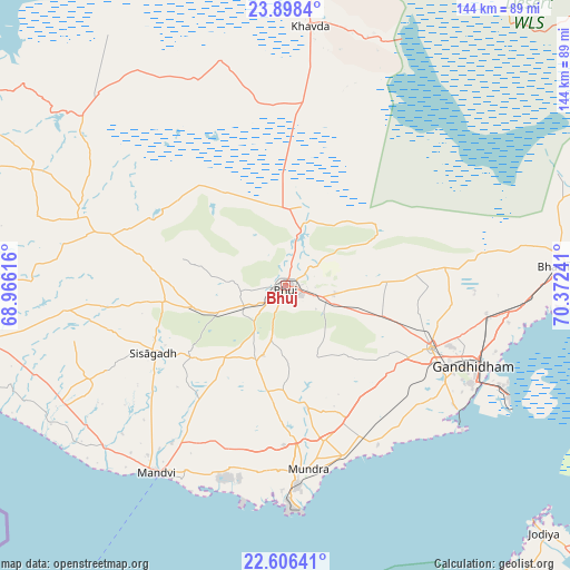
Bhuj GPS coordinates[2]
23° 15' 14.292" North, 69° 40' 9.408" East
| Map corner | latitude | longitude |
|---|---|---|
| Upper-left | 23.8984°, | 68.96616° |
| Center: | 23.25397°, | 69.66928° |
| Lower-right: | 22.60641°, | 70.37241° |
| Map W x H: | 143.7×143.7 km | = 89.3×89.3mi |
| max Lat: | 34.9274° ⇑46.7% North |
| Bhuj: | 23.25397° |
| min Lat: | ⇓53.3% South 8.09008° |
| min Long | Bhuj | max Long |
| 68.82655° | 69.66928° | 96.81° |
| W 0.3%⇐ | ⇒99.7% E |
Elevation
Elevation of Bhuj is 106 m = 348 ft, and this is 189.6 m = 622 ft below average elevation for this country.
| Max E: |
3681 m = 12077 ft | 67.2% |
| Avg. | 295.6 m = 970 ft | |
| Bhuj | 106 m = 348 ft | |
Min E: |
1 m = 3 ft | 32.8% |
See also: Bhuj elevation on elevation.city.
Geographical zone
Bhuj is located in North Torrid zone (between Equator and Tropic of Cancer). Distance of this Northern Tropic circle is 20.3 km =12.6 mi to North.| Distance of | km | miles | from Bhuj |
|---|---|---|---|
| North Pole | 7421.5 | 4611.5 | to North |
| Arctic Circle | 4815.6 | 2992.3 | to North |
| Tropic Cancer | 20.3 | 12.6 | to North |
| Equator | 2585.6 | 1606.6 | to South |


Nearby cities:
15 places around Bhuj: (largest is in red/bold)
• Anjār
39.7 km =24.7 mi,  113°
113°
• Bedi
92 km =57.2 mi,  155°
155°
• Bhachāu
69 km =42.9 mi,  85°
85°
• Dayapar
88.9 km =55.2 mi,  298°
298°
• Gāndhīdhām
51.1 km =31.8 mi, 111°
• Jamnagar
95.9 km =59.6 mi,  154°
154°
• Jodiya Bandar
86.7 km =53.9 mi,  133°
133°
• Kāndla
61.1 km =38 mi, 113°
• Mundra
46.4 km =28.8 mi,  173°
173°
• Māndvi
57 km =35.4 mi,  214°
214°
• Naliya
86.1 km =53.5 mi,  270°
270°
• Roha
41.2 km =25.6 mi,  261°
261°
• Rāpar
105.9 km =65.8 mi,  70°
70°
• Salāya
105.1 km =65.3 mi,  183°
183°
• Sikka
93.1 km =57.8 mi, 169°
Sources, notices
• [Note1] Compared only with cities in India existing in our database
• [Src1] Map data: © OpenStreetMap contributors (CC-BY-SA)
• [Src2] Other city data from geonames.org with taken over terms of usage.
• [Src3] Geographical zone / Annual Mean Temperature by Robert A. Rohde @ Wikipedia
