Obra geodata
Obra (Uttar Pradesh) is a populated place; located in India in Asia/Kolkata (GMT+5.5) time zone. With population of 56,110 people, there are 792 cities with bigger population in this country. Compared to other cities in India, 60.2% of cities are located further ↓South; 79.2% of cities are located further ←West and 50.5% of cities have lower elevation than Obra. Note1


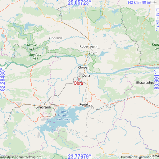
Obra GPS coordinates[2]
24° 25' 7.068" North, 82° 59' 16.692" East
| Map corner | latitude | longitude |
|---|---|---|
| Upper-left | 25.05723°, | 82.28485° |
| Center: | 24.41863°, | 82.98797° |
| Lower-right: | 23.77679°, | 83.6911° |
| Map W x H: | 142.4×142.4 km | = 88.5×88.5mi |
| max Lat: | 34.9274° ⇑39.8% North |
| Obra: | 24.41863° |
| min Lat: | ⇓60.2% South 8.09008° |
| min Long | Obra | max Long |
| 68.82655° | 82.98797° | 96.81° |
| W 79.2%⇐ | ⇒20.8% E |
Elevation
Elevation of Obra is 205 m = 673 ft, and this is 90.6 m = 297 ft below average elevation for this country.
| Max E: |
3681 m = 12077 ft | 49.5% |
| Avg. | 295.6 m = 970 ft | |
| Obra | 205 m = 673 ft | |
Min E: |
1 m = 3 ft | 50.5% |
See also: Obra elevation on elevation.city.
Geographical zone
Obra is located in North temperate zone (between Tropic of Cancer and the Arctic Circle). Distance of this Northern Tropic circle is 109.2 km =67.9 mi to South.| Distance of | km | miles | from Obra |
|---|---|---|---|
| North Pole | 7292 | 4531 | to North |
| Arctic Circle | 4686.1 | 2911.8 | to North |
| Tropic Cancer | 109.2 | 67.9 | to South |
| Equator | 2715.1 | 1687.1 | to South |


Nearby cities:
15 places around Obra: (largest is in red/bold)
• Ahraura
66.6 km =41.4 mi,  3°
3°
• Bhabhua
93.2 km =57.9 mi,  42°
42°
• Chakia
73.9 km =45.9 mi,  18°
18°
• Chopan
11.8 km =7.3 mi, 17°
• Chunār
79.6 km =49.5 mi,  352°
352°
• Dūdhi
34.3 km =21.3 mi,  131°
131°
• Garhwa
87.9 km =54.6 mi,  109°
109°
• Ghorāwal
42.9 km =26.7 mi,  330°
330°
• Kachhwa
91.8 km =57 mi,  342°
342°
• Kota
14.8 km =9.2 mi,  77°
77°
• Mirzāpur
91.3 km =56.7 mi, 332°
• Renukūt
23 km =14.3 mi,  167°
167°
• Robertsganj
31.1 km =19.3 mi, 15°
• Rāmnagar
94.7 km =58.8 mi, 2°
• Singrauli
39.9 km =24.8 mi,  232°
232°
Sources, notices
• [Note1] Compared only with cities in India existing in our database
• [Src1] Map data: © OpenStreetMap contributors (CC-BY-SA)
• [Src2] Other city data from geonames.org with taken over terms of usage.
• [Src3] Geographical zone / Annual Mean Temperature by Robert A. Rohde @ Wikipedia
