Chopan geodata
Chopan (Uttar Pradesh) is a populated place; located in India in Asia/Kolkata (GMT+5.5) time zone. With population of 13,585 people, there are 2605 cities with bigger population in this country. Compared to other cities in India, 60.8% of cities are located further ↓South; 79.3% of cities are located further ←West and 50.8% of cities have higher elevation than Chopan. Note1


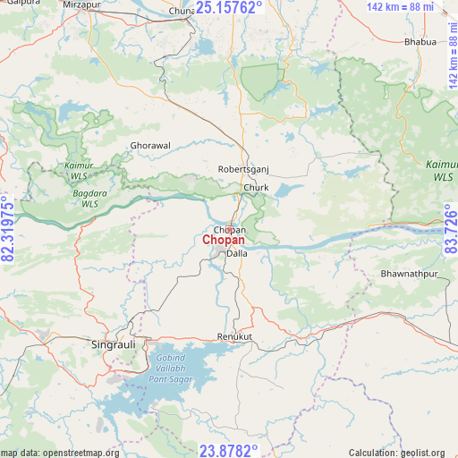
Chopan GPS coordinates[2]
24° 31' 10.344" North, 83° 1' 22.332" East
| Map corner | latitude | longitude |
|---|---|---|
| Upper-left | 25.15762°, | 82.31975° |
| Center: | 24.51954°, | 83.02287° |
| Lower-right: | 23.8782°, | 83.726° |
| Map W x H: | 142.3×142.3 km | = 88.4×88.4mi |
| max Lat: | 34.9274° ⇑39.2% North |
| Chopan: | 24.51954° |
| min Lat: | ⇓60.8% South 8.09008° |
| min Long | Chopan | max Long |
| 68.82655° | 83.02287° | 96.81° |
| W 79.3%⇐ | ⇒20.7% E |
Elevation
Elevation of Chopan is 198 m = 650 ft, and this is 97.6 m = 320 ft below average elevation for this country.
| Max E: |
3681 m = 12077 ft | 50.8% |
| Avg. | 295.6 m = 970 ft | |
| Chopan | 198 m = 650 ft | |
Min E: |
1 m = 3 ft | 49.2% |
See also: India elevation on elevation.city.
Geographical zone
Chopan is located in North temperate zone (between Tropic of Cancer and the Arctic Circle). Distance of this Northern Tropic circle is 120.4 km =74.8 mi to South.| Distance of | km | miles | from Chopan |
|---|---|---|---|
| North Pole | 7280.7 | 4524 | to North |
| Arctic Circle | 4674.9 | 2904.8 | to North |
| Tropic Cancer | 120.4 | 74.8 | to South |
| Equator | 2726.3 | 1694 | to South |


Nearby cities:
15 places around Chopan: (largest is in red/bold)
• Ahraura
55.2 km =34.3 mi,  1°
1°
• Bhabhua
82.7 km =51.4 mi,  45°
45°
• Chakia
62.2 km =38.6 mi,  18°
18°
• Chunār
69.1 km =42.9 mi,  348°
348°
• Dūdhi
40.5 km =25.2 mi,  147°
147°
• Ghorāwal
35.9 km =22.3 mi,  316°
316°
• Kachhwa
82.4 km =51.2 mi,  337°
337°
• Kota
13.6 km =8.5 mi,  126°
126°
• Mirzāpur
83.5 km =51.9 mi,  326°
326°
• Mughal Sarāi
85.5 km =53.1 mi,  6°
6°
• Obra
11.8 km =7.3 mi,  197°
197°
• Renukūt
33.7 km =20.9 mi,  177°
177°
• Robertsganj
19.3 km =12 mi, 13°
• Rāmnagar
83.3 km =51.8 mi, 0°
• Singrauli
50 km =31.1 mi,  224°
224°
Sources, notices
• [Note1] Compared only with cities in India existing in our database
• [Src1] Map data: © OpenStreetMap contributors (CC-BY-SA)
• [Src2] Other city data from geonames.org with taken over terms of usage.
• [Src3] Geographical zone / Annual Mean Temperature by Robert A. Rohde @ Wikipedia
