Bhabhua geodata
Bhabhua (Bihar) is a populated place; located in India in Asia/Kolkata (GMT+5.5) time zone. With population of 48,641 people, there are 908 cities with bigger population in this country. Compared to other cities in India, 63.7% of cities are located further ↓South; 81% of cities are located further ←West and 71% of cities have higher elevation than Bhabhua. Note1


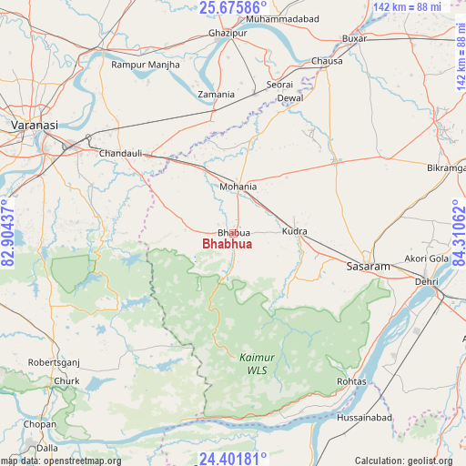
Bhabhua GPS coordinates[2]
25° 2' 25.764" North, 83° 36' 26.964" East
| Map corner | latitude | longitude |
|---|---|---|
| Upper-left | 25.67586°, | 82.90437° |
| Center: | 25.04049°, | 83.60749° |
| Lower-right: | 24.40181°, | 84.31062° |
| Map W x H: | 141.7×141.7 km | = 88×88mi |
| max Lat: | 34.9274° ⇑36.3% North |
| Bhabhua: | 25.04049° |
| min Lat: | ⇓63.7% South 8.09008° |
| min Long | Bhabhua | max Long |
| 68.82655° | 83.60749° | 96.81° |
| W 81%⇐ | ⇒19% E |
Elevation
Elevation of Bhabhua is 88 m = 289 ft, and this is 207.6 m = 681 ft below average elevation for this country.
| Max E: |
3681 m = 12077 ft | 71% |
| Avg. | 295.6 m = 970 ft | |
| Bhabhua | 88 m = 289 ft | |
Min E: |
1 m = 3 ft | 29% |
See also: Bhabhua elevation on elevation.city.
Geographical zone
Bhabhua is located in North temperate zone (between Tropic of Cancer and the Arctic Circle). Distance of this Northern Tropic circle is 178.3 km =110.8 mi to South.| Distance of | km | miles | from Bhabhua |
|---|---|---|---|
| North Pole | 7222.8 | 4488 | to North |
| Arctic Circle | 4616.9 | 2868.8 | to North |
| Tropic Cancer | 178.3 | 110.8 | to South |
| Equator | 2784.2 | 1730 | to South |


Nearby cities:
15 places around Bhabhua: (largest is in red/bold)
• Ahraura
58 km =36 mi,  267°
267°
• Bikramganj
67.9 km =42.2 mi,  73°
73°
• Buxar
70.3 km =43.7 mi,  32°
32°
• Chakia
38.9 km =24.2 mi, 271°
• Chandauli
41.8 km =26 mi,  305°
305°
• Dehri
59.9 km =37.2 mi,  104°
104°
• Ghazīpur
60.4 km =37.5 mi,  357°
357°
• Husainābād
69.4 km =43.1 mi,  145°
145°
• Mughal Sarāi
56 km =34.8 mi,  298°
298°
• Muhammadābād
66 km =41 mi,  13°
13°
• Robertsganj
67 km =41.6 mi,  234°
234°
• Rāmnagar
63.5 km =39.5 mi,  293°
293°
• Saidpur
67.4 km =41.9 mi,  325°
325°
• Varanasi
67.5 km =41.9 mi, 297°
• Zamānia
42.4 km =26.3 mi,  353°
353°
Sources, notices
• [Note1] Compared only with cities in India existing in our database
• [Src1] Map data: © OpenStreetMap contributors (CC-BY-SA)
• [Src2] Other city data from geonames.org with taken over terms of usage.
• [Src3] Geographical zone / Annual Mean Temperature by Robert A. Rohde @ Wikipedia
