Mirzāpur geodata
Mirzāpur (Uttar Pradesh) is a populated place; located in India in Asia/Kolkata (GMT+5.5) time zone. With population of 220,029 people, there are 194 cities with bigger population in this country. Compared to other cities in India, 64.1% of cities are located further ↓South; 78.1% of cities are located further ←West and 70.5% of cities have higher elevation than Mirzāpur. Note1


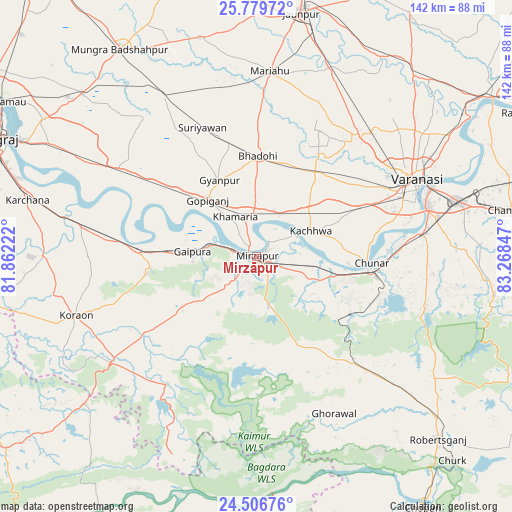
Mirzāpur GPS coordinates[2]
25° 8' 41.64" North, 82° 33' 55.224" East
| Map corner | latitude | longitude |
|---|---|---|
| Upper-left | 25.77972°, | 81.86222° |
| Center: | 25.1449°, | 82.56534° |
| Lower-right: | 24.50676°, | 83.26847° |
| Map W x H: | 141.5×141.5 km | = 87.9×87.9mi |
| max Lat: | 34.9274° ⇑35.9% North |
| Mirzāpur: | 25.1449° |
| min Lat: | ⇓64.1% South 8.09008° |
| min Long | Mirzāpur | max Long |
| 68.82655° | 82.56534° | 96.81° |
| W 78.1%⇐ | ⇒21.9% E |
Elevation
Elevation of Mirzāpur is 90 m = 295 ft, and this is 205.6 m = 675 ft below average elevation for this country.
| Max E: |
3681 m = 12077 ft | 70.5% |
| Avg. | 295.6 m = 970 ft | |
| Mirzāpur | 90 m = 295 ft | |
Min E: |
1 m = 3 ft | 29.5% |
See also: Mirzāpur elevation on elevation.city.
Geographical zone
Mirzāpur is located in North temperate zone (between Tropic of Cancer and the Arctic Circle). Distance of this Northern Tropic circle is 189.9 km =118 mi to South.| Distance of | km | miles | from Mirzāpur |
|---|---|---|---|
| North Pole | 7211.2 | 4480.8 | to North |
| Arctic Circle | 4605.3 | 2861.6 | to North |
| Tropic Cancer | 189.9 | 118 | to South |
| Equator | 2795.9 | 1737.3 | to South |


Nearby cities:
15 places around Mirzāpur: (largest is in red/bold)
• Ahraura
49.2 km =30.6 mi,  106°
106°
• Barāgaon
40.5 km =25.2 mi,  38°
38°
• Bhadohi
27.8 km =17.3 mi,  1°
1°
• Chunār
31.9 km =19.8 mi,  93°
93°
• Ghorāwal
48.5 km =30.1 mi,  153°
153°
• Gyānpur
23.1 km =14.4 mi,  334°
334°
• Handiā
45.2 km =28.1 mi,  302°
302°
• Kachhwa
16.5 km =10.3 mi,  65°
65°
• Machhlīshahr
62.1 km =38.6 mi,  345°
345°
• Mariāhu
51.2 km =31.8 mi, 4°
• Mughal Sarāi
57.8 km =35.9 mi, 74°
• Rāmnagar
48.7 km =30.3 mi, 73°
• Sirsā
49.4 km =30.7 mi,  285°
285°
• Suriānwān
38.4 km =23.9 mi,  337°
337°
• Varanasi
48.7 km =30.3 mi, 66°
Sources, notices
• [Note1] Compared only with cities in India existing in our database
• [Src1] Map data: © OpenStreetMap contributors (CC-BY-SA)
• [Src2] Other city data from geonames.org with taken over terms of usage.
• [Src3] Geographical zone / Annual Mean Temperature by Robert A. Rohde @ Wikipedia
