Dūdhi geodata
Dūdhi (Uttar Pradesh) is a populated place; located in India in Asia/Kolkata (GMT+5.5) time zone. With population of 12,742 people, there are 2674 cities with bigger population in this country. Compared to other cities in India, 59.1% of cities are located further ↓South; 80.1% of cities are located further ←West and 59.9% of cities have lower elevation than Dūdhi. Note1


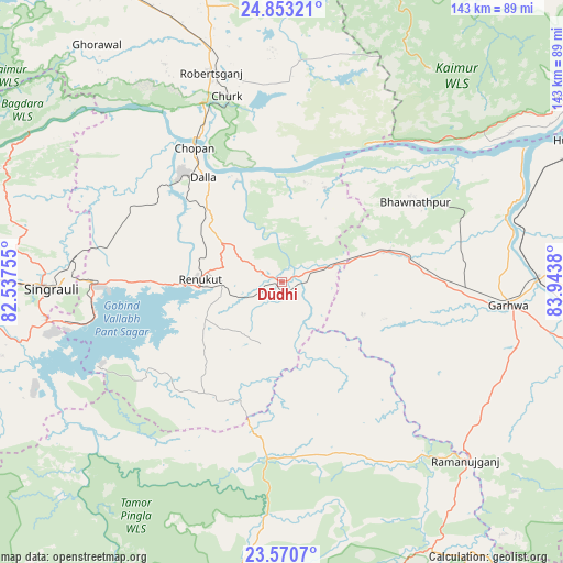
Dūdhi GPS coordinates[2]
24° 12' 48.852" North, 83° 14' 26.412" East
| Map corner | latitude | longitude |
|---|---|---|
| Upper-left | 24.85321°, | 82.53755° |
| Center: | 24.21357°, | 83.24067° |
| Lower-right: | 23.5707°, | 83.9438° |
| Map W x H: | 142.6×142.6 km | = 88.6×88.6mi |
| max Lat: | 34.9274° ⇑40.9% North |
| Dūdhi: | 24.21357° |
| min Lat: | ⇓59.1% South 8.09008° |
| min Long | Dūdhi | max Long |
| 68.82655° | 83.24067° | 96.81° |
| W 80.1%⇐ | ⇒19.9% E |
Elevation
Elevation of Dūdhi is 250 m = 820 ft, and this is 45.6 m = 150 ft below average elevation for this country.
| Max E: |
3681 m = 12077 ft | 40.1% |
| Avg. | 295.6 m = 970 ft | |
| Dūdhi | 250 m = 820 ft | |
Min E: |
1 m = 3 ft | 59.9% |
See also: India elevation on elevation.city.
Geographical zone
Dūdhi is located in North temperate zone (between Tropic of Cancer and the Arctic Circle). Distance of this Northern Tropic circle is 86.4 km =53.7 mi to South.| Distance of | km | miles | from Dūdhi |
|---|---|---|---|
| North Pole | 7314.8 | 4545.2 | to North |
| Arctic Circle | 4708.9 | 2926 | to North |
| Tropic Cancer | 86.4 | 53.7 | to South |
| Equator | 2692.3 | 1672.9 | to South |


Nearby cities:
15 places around Dūdhi: (largest is in red/bold)
• Ahraura
91.6 km =56.9 mi,  346°
346°
• Balrampur
76.7 km =47.7 mi,  150°
150°
• Barwādih
97.2 km =60.4 mi,  114°
114°
• Chakia
92.9 km =57.7 mi,  358°
358°
• Chopan
40.5 km =25.2 mi,  327°
327°
• Daltonganj
85.9 km =53.4 mi,  103°
103°
• Garhwa
57.8 km =35.9 mi, 95°
• Ghorāwal
76.1 km =47.3 mi,  322°
322°
• Husainābād
84.5 km =52.5 mi,  65°
65°
• Kota
28.2 km =17.5 mi,  336°
336°
• Obra
34.3 km =21.3 mi,  311°
311°
• Renukūt
20.8 km =12.9 mi,  270°
270°
• Robertsganj
55.6 km =34.5 mi, 341°
• Rāmānuj Ganj
65 km =40.4 mi,  134°
134°
• Singrauli
57.4 km =35.7 mi, 268°
Sources, notices
• [Note1] Compared only with cities in India existing in our database
• [Src1] Map data: © OpenStreetMap contributors (CC-BY-SA)
• [Src2] Other city data from geonames.org with taken over terms of usage.
• [Src3] Geographical zone / Annual Mean Temperature by Robert A. Rohde @ Wikipedia
