Ahraura geodata
Ahraura (Uttar Pradesh) is a populated place; located in India in Asia/Kolkata (GMT+5.5) time zone. With population of 25,075 people, there are 1693 cities with bigger population in this country. Compared to other cities in India, 63.5% of cities are located further ↓South; 79.4% of cities are located further ←West and 67.2% of cities have higher elevation than Ahraura. Note1


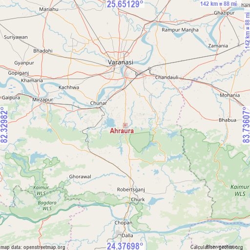
Ahraura GPS coordinates[2]
25° 0' 56.844" North, 83° 1' 58.584" East
| Map corner | latitude | longitude |
|---|---|---|
| Upper-left | 25.65129°, | 82.32982° |
| Center: | 25.01579°, | 83.03294° |
| Lower-right: | 24.37698°, | 83.73607° |
| Map W x H: | 141.7×141.7 km | = 88×88mi |
| max Lat: | 34.9274° ⇑36.5% North |
| Ahraura: | 25.01579° |
| min Lat: | ⇓63.5% South 8.09008° |
| min Long | Ahraura | max Long |
| 68.82655° | 83.03294° | 96.81° |
| W 79.4%⇐ | ⇒20.6% E |
Elevation
Elevation of Ahraura is 106 m = 348 ft, and this is 189.6 m = 622 ft below average elevation for this country.
| Max E: |
3681 m = 12077 ft | 67.2% |
| Avg. | 295.6 m = 970 ft | |
| Ahraura | 106 m = 348 ft | |
Min E: |
1 m = 3 ft | 32.8% |
See also: India elevation on elevation.city.
Geographical zone
Ahraura is located in North temperate zone (between Tropic of Cancer and the Arctic Circle). Distance of this Northern Tropic circle is 175.6 km =109.1 mi to South.| Distance of | km | miles | from Ahraura |
|---|---|---|---|
| North Pole | 7225.6 | 4489.8 | to North |
| Arctic Circle | 4619.7 | 2870.5 | to North |
| Tropic Cancer | 175.6 | 109.1 | to South |
| Equator | 2781.5 | 1728.3 | to South |


Nearby cities:
15 places around Ahraura: (largest is in red/bold)
• Barāgaon
50.9 km =31.6 mi,  334°
334°
• Bhabhua
58 km =36 mi,  87°
87°
• Bhadohi
62.8 km =39 mi,  312°
312°
• Chakia
19.4 km =12.1 mi,  79°
79°
• Chandauli
35.9 km =22.3 mi,  41°
41°
• Chopan
55.2 km =34.3 mi,  181°
181°
• Chunār
19.6 km =12.2 mi, 309°
• Ghorāwal
38.7 km =24 mi,  221°
221°
• Kachhwa
38.4 km =23.9 mi,  303°
303°
• Mirzāpur
49.2 km =30.6 mi,  286°
286°
• Mughal Sarāi
31 km =19.3 mi,  16°
16°
• Robertsganj
36.6 km =22.7 mi,  174°
174°
• Rāmnagar
28.2 km =17.5 mi,  359°
359°
• Saidpur
61.1 km =38 mi, 18°
• Varanasi
33.5 km =20.8 mi, 356°
Sources, notices
• [Note1] Compared only with cities in India existing in our database
• [Src1] Map data: © OpenStreetMap contributors (CC-BY-SA)
• [Src2] Other city data from geonames.org with taken over terms of usage.
• [Src3] Geographical zone / Annual Mean Temperature by Robert A. Rohde @ Wikipedia
