Robertsganj geodata
Robertsganj (Uttar Pradesh) is a populated place; located in India in Asia/Kolkata (GMT+5.5) time zone. With population of 37,855 people, there are 1162 cities with bigger population in this country. Compared to other cities in India, 61.7% of cities are located further ↓South; 79.5% of cities are located further ←West and 69.4% of cities have lower elevation than Robertsganj. Note1


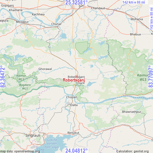
Robertsganj GPS coordinates[2]
24° 41' 18.96" North, 83° 4' 4.224" East
| Map corner | latitude | longitude |
|---|---|---|
| Upper-left | 25.32581°, | 82.36472° |
| Center: | 24.6886°, | 83.06784° |
| Lower-right: | 24.04812°, | 83.77097° |
| Map W x H: | 142.1×142.1 km | = 88.3×88.3mi |
| max Lat: | 34.9274° ⇑38.3% North |
| Robertsganj: | 24.6886° |
| min Lat: | ⇓61.7% South 8.09008° |
| min Long | Robertsganj | max Long |
| 68.82655° | 83.06784° | 96.81° |
| W 79.5%⇐ | ⇒20.5% E |
Elevation
Elevation of Robertsganj is 321 m = 1053 ft, and this is 25.4 m = 83 ft above average elevation for this country.
| Max E: |
3681 m = 12077 ft | 30.6% |
| Robertsganj | 321 m 1053 ft | |
| Avg. | 295.6 m = 970 ft | |
Min E: |
1 m = 3 ft | 69.4% |
See also: India elevation on elevation.city.
Geographical zone
Robertsganj is located in North temperate zone (between Tropic of Cancer and the Arctic Circle). Distance of this Northern Tropic circle is 139.2 km =86.5 mi to South.| Distance of | km | miles | from Robertsganj |
|---|---|---|---|
| North Pole | 7261.9 | 4512.3 | to North |
| Arctic Circle | 4656.1 | 2893.2 | to North |
| Tropic Cancer | 139.2 | 86.5 | to South |
| Equator | 2745.1 | 1705.7 | to South |


Nearby cities:
15 places around Robertsganj: (largest is in red/bold)
• Ahraura
36.6 km =22.7 mi,  354°
354°
• Bhabhua
67 km =41.6 mi,  54°
54°
• Chakia
43 km =26.7 mi,  21°
21°
• Chandauli
66.5 km =41.3 mi, 17°
• Chopan
19.3 km =12 mi,  193°
193°
• Chunār
52.3 km =32.5 mi,  339°
339°
• Dūdhi
55.6 km =34.5 mi,  161°
161°
• Ghorāwal
30 km =18.6 mi,  284°
284°
• Kachhwa
67.7 km =42.1 mi,  328°
328°
• Kota
27.7 km =17.2 mi,  166°
166°
• Mughal Sarāi
66.3 km =41.2 mi,  4°
4°
• Obra
31.1 km =19.3 mi,  195°
195°
• Renukūt
52.6 km =32.7 mi,  183°
183°
• Rāmnagar
64.7 km =40.2 mi,  356°
356°
• Singrauli
67.3 km =41.8 mi,  216°
216°
Sources, notices
• [Note1] Compared only with cities in India existing in our database
• [Src1] Map data: © OpenStreetMap contributors (CC-BY-SA)
• [Src2] Other city data from geonames.org with taken over terms of usage.
• [Src3] Geographical zone / Annual Mean Temperature by Robert A. Rohde @ Wikipedia
