Bokajān geodata
Bokajān (Assam) is a populated place; located in India in Asia/Kolkata (GMT+5.5) time zone. With population of 16,561 people, there are 2324 cities with bigger population in this country. Compared to other cities in India, 70.4% of cities are located further ↓South; 98.4% of cities are located further ←West and 61.9% of cities have higher elevation than Bokajān. Note1


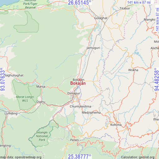
Bokajān GPS coordinates[2]
26° 1' 16.716" North, 93° 46' 46.02" East
| Map corner | latitude | longitude |
|---|---|---|
| Upper-left | 26.65145°, | 93.07633° |
| Center: | 26.02131°, | 93.77945° |
| Lower-right: | 25.38777°, | 94.48258° |
| Map W x H: | 140.5×140.5 km | = 87.3×87.3mi |
| max Lat: | 34.9274° ⇑29.6% North |
| Bokajān: | 26.02131° |
| min Lat: | ⇓70.4% South 8.09008° |
| min Long | Bokajān | max Long |
| 68.82655° | 93.77945° | 96.81° |
| W 98.4%⇐ | ⇒1.6% E |
Elevation
Elevation of Bokajān is 138 m = 453 ft, and this is 157.6 m = 517 ft below average elevation for this country.
| Max E: |
3681 m = 12077 ft | 61.9% |
| Avg. | 295.6 m = 970 ft | |
| Bokajān | 138 m = 453 ft | |
Min E: |
1 m = 3 ft | 38.1% |
See also: India elevation on elevation.city.
Geographical zone
Bokajān is located in North temperate zone (between Tropic of Cancer and the Arctic Circle). Distance of this Northern Tropic circle is 287.4 km =178.6 mi to South.| Distance of | km | miles | from Bokajān |
|---|---|---|---|
| North Pole | 7113.8 | 4420.3 | to North |
| Arctic Circle | 4507.9 | 2801.1 | to North |
| Tropic Cancer | 287.4 | 178.6 | to South |
| Equator | 2893.3 | 1797.8 | to South |


Nearby cities:
15 places around Bokajān: (largest is in red/bold)
• Barpathār
31.5 km =19.6 mi,  20°
20°
• Bokākhāt
71.1 km =44.2 mi,  345°
345°
• Dergaon
77.7 km =48.3 mi,  13°
13°
• Dimāpur
13.5 km =8.4 mi,  205°
205°
• Diphu
40.1 km =24.9 mi,  240°
240°
• Golāghāt
57.4 km =35.7 mi, 18°
• Kohima
50.9 km =31.6 mi,  139°
139°
• Lumding Railway Colony
68.1 km =42.3 mi, 243°
• Mariāni
88.6 km =55.1 mi,  37°
37°
• Mokokchūng
81.1 km =50.4 mi,  65°
65°
• Numāligarh
67.1 km =41.7 mi,  355°
355°
• Phek
82.2 km =51.1 mi,  118°
118°
• Titābar
77.1 km =47.9 mi,  33°
33°
• Wokha
48.6 km =30.2 mi,  79°
79°
• Zunheboto
73.9 km =45.9 mi,  94°
94°
Sources, notices
• [Note1] Compared only with cities in India existing in our database
• [Src1] Map data: © OpenStreetMap contributors (CC-BY-SA)
• [Src2] Other city data from geonames.org with taken over terms of usage.
• [Src3] Geographical zone / Annual Mean Temperature by Robert A. Rohde @ Wikipedia
