Ziro geodata
Ziro (Arunachal Pradesh) is a populated place; located in India in Asia/Kolkata (GMT+5.5) time zone. With population of 13,893 people, there are 2575 cities with bigger population in this country. Compared to other cities in India, 82.5% of cities are located further ↓South; 98.4% of cities are located further ←West and 98% of cities have lower elevation than Ziro. Note1


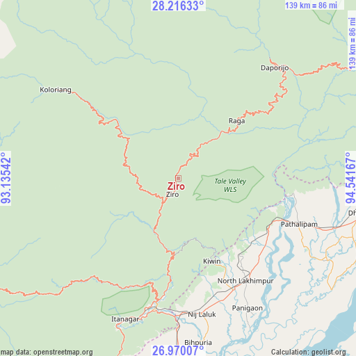
Ziro GPS coordinates[2]
27° 35' 41.892" North, 93° 50' 18.744" East
| Map corner | latitude | longitude |
|---|---|---|
| Upper-left | 28.21633°, | 93.13542° |
| Center: | 27.59497°, | 93.83854° |
| Lower-right: | 26.97007°, | 94.54167° |
| Map W x H: | 138.6×138.6 km | = 86.1×86.1mi |
| max Lat: | 34.9274° ⇑17.5% North |
| Ziro: | 27.59497° |
| min Lat: | ⇓82.5% South 8.09008° |
| min Long | Ziro | max Long |
| 68.82655° | 93.83854° | 96.81° |
| W 98.4%⇐ | ⇒1.6% E |
Elevation
Elevation of Ziro is 1579 m = 5180 ft, and this is 1283.4 m = 4211 ft above average elevation for this country.
| Max E: |
3681 m = 12077 ft | 2% |
| Ziro | 1579 m 5180 ft | |
| Avg. | 295.6 m = 970 ft | |
Min E: |
1 m = 3 ft | 98% |
See also: India elevation on elevation.city.
Geographical zone
Ziro is located in North temperate zone (between Tropic of Cancer and the Arctic Circle). Distance of this Northern Tropic circle is 462.4 km =287.3 mi to South.| Distance of | km | miles | from Ziro |
|---|---|---|---|
| North Pole | 6938.8 | 4311.6 | to North |
| Arctic Circle | 4332.9 | 2692.3 | to North |
| Tropic Cancer | 462.4 | 287.3 | to South |
| Equator | 3068.3 | 1906.6 | to South |


Nearby cities:
15 places around Ziro: (largest is in red/bold)
• Bihpuriāgaon
64.7 km =40.2 mi,  173°
173°
• Bokākhāt
108.7 km =67.5 mi,  192°
192°
• Bāsār
95 km =59 mi,  62°
62°
• Dergaon
100.3 km =62.3 mi, 172°
• Dhemāji
74.5 km =46.3 mi,  99°
99°
• Dibrugarh
106.3 km =66.1 mi, 96°
• Garamur
79 km =49.1 mi,  155°
155°
• Gohpur
82.3 km =51.1 mi,  195°
195°
• Itānagar
60.8 km =37.8 mi, 201°
• Jorhāt
99.9 km =62.1 mi, 158°
• Naharlagun
56.3 km =35 mi, 194°
• North Lakhimpur
47.8 km =29.7 mi,  146°
146°
• Numāligarh
108.7 km =67.5 mi, 186°
• Sibsāgar
104.2 km =64.7 mi,  130°
130°
• Silapathar
87.3 km =54.2 mi,  90°
90°
Sources, notices
• [Note1] Compared only with cities in India existing in our database
• [Src1] Map data: © OpenStreetMap contributors (CC-BY-SA)
• [Src2] Other city data from geonames.org with taken over terms of usage.
• [Src3] Geographical zone / Annual Mean Temperature by Robert A. Rohde @ Wikipedia
