Dhemāji geodata
Dhemāji (Assam) is a populated place; located in India in Asia/Kolkata (GMT+5.5) time zone. With population of 13,058 people, there are 2650 cities with bigger population in this country. Compared to other cities in India, 81.7% of cities are located further ↓South; 99.2% of cities are located further ←West and 66.4% of cities have higher elevation than Dhemāji. Note1


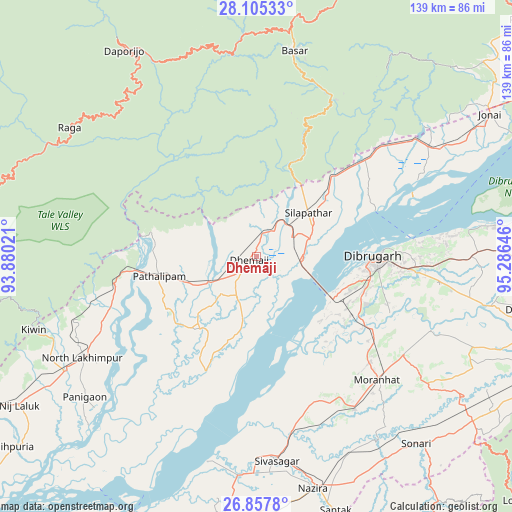
Dhemāji GPS coordinates[2]
27° 28' 59.988" North, 94° 34' 59.988" East
| Map corner | latitude | longitude |
|---|---|---|
| Upper-left | 28.10533°, | 93.88021° |
| Center: | 27.48333°, | 94.58333° |
| Lower-right: | 26.8578°, | 95.28646° |
| Map W x H: | 138.7×138.7 km | = 86.2×86.2mi |
| max Lat: | 34.9274° ⇑18.3% North |
| Dhemāji: | 27.48333° |
| min Lat: | ⇓81.7% South 8.09008° |
| min Long | Dhemāji | max Long |
| 68.82655° | 94.58333° | 96.81° |
| W 99.2%⇐ | ⇒0.8% E |
Elevation
Elevation of Dhemāji is 110 m = 361 ft, and this is 185.6 m = 609 ft below average elevation for this country.
| Max E: |
3681 m = 12077 ft | 66.4% |
| Avg. | 295.6 m = 970 ft | |
| Dhemāji | 110 m = 361 ft | |
Min E: |
1 m = 3 ft | 33.6% |
See also: India elevation on elevation.city.
Geographical zone
Dhemāji is located in North temperate zone (between Tropic of Cancer and the Arctic Circle). Distance of this Northern Tropic circle is 449.9 km =279.6 mi to South.| Distance of | km | miles | from Dhemāji |
|---|---|---|---|
| North Pole | 6951.2 | 4319.3 | to North |
| Arctic Circle | 4345.3 | 2700 | to North |
| Tropic Cancer | 449.9 | 279.6 | to South |
| Equator | 3055.9 | 1898.8 | to South |


Nearby cities:
15 places around Dhemāji: (largest is in red/bold)
• Amguri
74.5 km =46.3 mi,  184°
184°
• Bāsār
57.4 km =35.7 mi,  10°
10°
• Chābua
58.3 km =36.2 mi,  90°
90°
• Dibrugarh
32.1 km =19.9 mi, 90°
• Duliāgaon
72.5 km =45 mi,  99°
99°
• Garamur
72 km =44.7 mi,  214°
214°
• Morānha
46.5 km =28.9 mi,  135°
135°
• North Lakhimpur
54.8 km =34.1 mi,  239°
239°
• Nāzirā
64.8 km =40.3 mi,  166°
166°
• Sibsāgar
55.8 km =34.7 mi, 174°
• Silapathar
18.6 km =11.6 mi,  48°
48°
• Sonari
63.3 km =39.3 mi, 136°
• Sonāri
66.6 km =41.4 mi, 140°
• Tinsukia
76.6 km =47.6 mi, 89°
• Ziro
74.5 km =46.3 mi,  279°
279°
Sources, notices
• [Note1] Compared only with cities in India existing in our database
• [Src1] Map data: © OpenStreetMap contributors (CC-BY-SA)
• [Src2] Other city data from geonames.org with taken over terms of usage.
• [Src3] Geographical zone / Annual Mean Temperature by Robert A. Rohde @ Wikipedia
