Silapathar geodata
Silapathar (Assam) is a populated place; located in India in Asia/Kolkata (GMT+5.5) time zone. With population of 22,307 people, there are 1885 cities with bigger population in this country. Compared to other cities in India, 82.5% of cities are located further ↓South; 99.3% of cities are located further ←West and 65.2% of cities have higher elevation than Silapathar. Note1


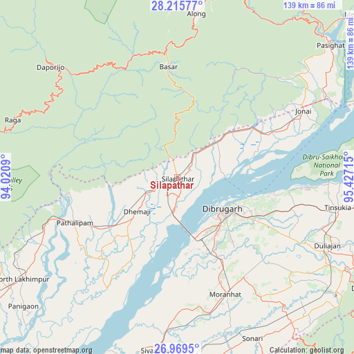
Silapathar GPS coordinates[2]
27° 35' 39.876" North, 94° 43' 26.472" East
| Map corner | latitude | longitude |
|---|---|---|
| Upper-left | 28.21577°, | 94.0209° |
| Center: | 27.59441°, | 94.72402° |
| Lower-right: | 26.9695°, | 95.42715° |
| Map W x H: | 138.6×138.6 km | = 86.1×86.1mi |
| max Lat: | 34.9274° ⇑17.5% North |
| Silapathar: | 27.59441° |
| min Lat: | ⇓82.5% South 8.09008° |
| min Long | Silapathar | max Long |
| 68.82655° | 94.72402° | 96.81° |
| W 99.3%⇐ | ⇒0.7% E |
Elevation
Elevation of Silapathar is 119 m = 390 ft, and this is 176.6 m = 579 ft below average elevation for this country.
| Max E: |
3681 m = 12077 ft | 65.2% |
| Avg. | 295.6 m = 970 ft | |
| Silapathar | 119 m = 390 ft | |
Min E: |
1 m = 3 ft | 34.8% |
See also: India elevation on elevation.city.
Geographical zone
Silapathar is located in North temperate zone (between Tropic of Cancer and the Arctic Circle). Distance of this Northern Tropic circle is 462.3 km =287.3 mi to South.| Distance of | km | miles | from Silapathar |
|---|---|---|---|
| North Pole | 6938.9 | 4311.6 | to North |
| Arctic Circle | 4333 | 2692.4 | to North |
| Tropic Cancer | 462.3 | 287.3 | to South |
| Equator | 3068.2 | 1906.5 | to South |


Nearby cities:
15 places around Silapathar: (largest is in red/bold)
• Along
64.4 km =40 mi,  6°
6°
• Bāsār
44.1 km =27.4 mi,  356°
356°
• Chābua
46.1 km =28.6 mi,  105°
105°
• Dhemāji
18.6 km =11.6 mi,  228°
228°
• Dibrugarh
22.2 km =13.8 mi,  125°
125°
• Duliāgaon
62.6 km =38.9 mi, 113°
• Morānha
49.1 km =30.5 mi,  157°
157°
• Mākum
71.3 km =44.3 mi,  99°
99°
• Nahorkatiya
69.8 km =43.4 mi,  119°
119°
• North Lakhimpur
73.1 km =45.4 mi,  236°
236°
• Pangin
73.2 km =45.5 mi,  20°
20°
• Sibsāgar
68.4 km =42.5 mi,  187°
187°
• Sonari
65.2 km =40.5 mi,  152°
152°
• Sonāri
69.6 km =43.2 mi, 155°
• Tinsukia
63.8 km =39.6 mi, 100°
Sources, notices
• [Note1] Compared only with cities in India existing in our database
• [Src1] Map data: © OpenStreetMap contributors (CC-BY-SA)
• [Src2] Other city data from geonames.org with taken over terms of usage.
• [Src3] Geographical zone / Annual Mean Temperature by Robert A. Rohde @ Wikipedia
