Nokha geodata
Nokha (Rajasthan) is a populated place; located in India in Asia/Kolkata (GMT+5.5) time zone. With population of 55,911 people, there are 798 cities with bigger population in this country. Compared to other cities in India, 82.3% of cities are located further ↓South; 92.6% of cities are located further →East and 69.3% of cities have lower elevation than Nokha. Note1


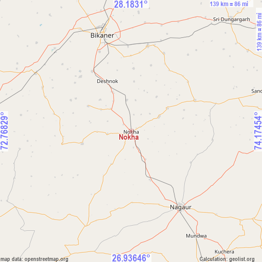
Nokha GPS coordinates[2]
27° 33' 41.58" North, 73° 28' 17.076" East
| Map corner | latitude | longitude |
|---|---|---|
| Upper-left | 28.1831°, | 72.76829° |
| Center: | 27.56155°, | 73.47141° |
| Lower-right: | 26.93646°, | 74.17454° |
| Map W x H: | 138.6×138.6 km | = 86.1×86.1mi |
| max Lat: | 34.9274° ⇑17.7% North |
| Nokha: | 27.56155° |
| min Lat: | ⇓82.3% South 8.09008° |
| min Long | Nokha | max Long |
| 68.82655° | 73.47141° | 96.81° |
| W 7.4%⇐ | ⇒92.6% E |
Elevation
Elevation of Nokha is 320 m = 1050 ft, and this is 24.4 m = 80 ft above average elevation for this country.
| Max E: |
3681 m = 12077 ft | 30.7% |
| Nokha | 320 m 1050 ft | |
| Avg. | 295.6 m = 970 ft | |
Min E: |
1 m = 3 ft | 69.3% |
See also: Nokha elevation on elevation.city.
Geographical zone
Nokha is located in North temperate zone (between Tropic of Cancer and the Arctic Circle). Distance of this Northern Tropic circle is 458.6 km =285 mi to South.| Distance of | km | miles | from Nokha |
|---|---|---|---|
| North Pole | 6942.5 | 4313.9 | to North |
| Arctic Circle | 4336.6 | 2694.6 | to North |
| Tropic Cancer | 458.6 | 285 | to South |
| Equator | 3064.6 | 1904.3 | to South |


Nearby cities:
15 places around Nokha: (largest is in red/bold)
• Basni
46.6 km =29 mi,  158°
158°
• Bhādāsar
116.1 km =72.1 mi,  43°
43°
• Bīkaner
53 km =32.9 mi,  343°
343°
• Chhāpar
99.5 km =61.8 mi,  73°
73°
• Deshnoke
29.2 km =18.1 mi,  334°
334°
• Dīdwāna
110.4 km =68.6 mi,  99°
99°
• Kuchera
80.7 km =50.1 mi,  142°
142°
• Lādnūn
92.1 km =57.2 mi,  83°
83°
• Merta
115.8 km =72 mi,  151°
151°
• Mūndwa
65.4 km =40.6 mi, 147°
• Napāsar
45.2 km =28.1 mi,  11°
11°
• Nāgaur
47.6 km =29.6 mi, 147°
• Rājaldesar
111.5 km =69.3 mi,  62°
62°
• Sri Dūngargarh
79.5 km =49.4 mi, 41°
• Sūjāngarh
99.2 km =61.6 mi, 81°
Sources, notices
• [Note1] Compared only with cities in India existing in our database
• [Src1] Map data: © OpenStreetMap contributors (CC-BY-SA)
• [Src2] Other city data from geonames.org with taken over terms of usage.
• [Src3] Geographical zone / Annual Mean Temperature by Robert A. Rohde @ Wikipedia
