Nāgaur geodata
Nāgaur (Rajasthan) is a populated place; located in India in Asia/Kolkata (GMT+5.5) time zone. With population of 96,847 people, there are 458 cities with bigger population in this country. Compared to other cities in India, 80.1% of cities are located further ↓South; 91.7% of cities are located further →East and 67.5% of cities have lower elevation than Nāgaur. Note1


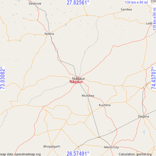
Nāgaur GPS coordinates[2]
27° 12' 7.236" North, 73° 44' 2.184" East
| Map corner | latitude | longitude |
|---|---|---|
| Upper-left | 27.82561°, | 73.03082° |
| Center: | 27.20201°, | 73.73394° |
| Lower-right: | 26.57491°, | 74.43707° |
| Map W x H: | 139.1×139.1 km | = 86.4×86.4mi |
| max Lat: | 34.9274° ⇑19.9% North |
| Nāgaur: | 27.20201° |
| min Lat: | ⇓80.1% South 8.09008° |
| min Long | Nāgaur | max Long |
| 68.82655° | 73.73394° | 96.81° |
| W 8.3%⇐ | ⇒91.7% E |
Elevation
Elevation of Nāgaur is 305 m = 1001 ft, and this is 9.4 m = 31 ft above average elevation for this country.
| Max E: |
3681 m = 12077 ft | 32.5% |
| Nāgaur | 305 m 1001 ft | |
| Avg. | 295.6 m = 970 ft | |
Min E: |
1 m = 3 ft | 67.5% |
See also: Nāgaur elevation on elevation.city.
Geographical zone
Nāgaur is located in North temperate zone (between Tropic of Cancer and the Arctic Circle). Distance of this Northern Tropic circle is 418.7 km =260.2 mi to South.| Distance of | km | miles | from Nāgaur |
|---|---|---|---|
| North Pole | 6982.5 | 4338.7 | to North |
| Arctic Circle | 4376.6 | 2719.5 | to North |
| Tropic Cancer | 418.7 | 260.2 | to South |
| Equator | 3024.6 | 1879.4 | to South |


Nearby cities:
15 places around Nāgaur: (largest is in red/bold)
• Basni
9.4 km =5.8 mi,  249°
249°
• Bīkaner
99.6 km =61.9 mi,  335°
335°
• Chhāpar
97.7 km =60.7 mi,  45°
45°
• Deshnoke
76.7 km =47.7 mi,  329°
329°
• Dīdwāna
86 km =53.4 mi,  75°
75°
• Kuchera
33.5 km =20.8 mi,  135°
135°
• Lādnūn
82.7 km =51.4 mi, 52°
• Makrāna
99.6 km =61.9 mi,  100°
100°
• Meethari Marwar
102.8 km =63.9 mi,  66°
66°
• Merta
68.4 km =42.5 mi,  154°
154°
• Mūndwa
17.8 km =11.1 mi, 150°
• Napāsar
86.1 km =53.5 mi,  348°
348°
• Nokha
47.6 km =29.6 mi, 327°
• Pīpār
92.8 km =57.7 mi,  191°
191°
• Sūjāngarh
91.1 km =56.6 mi, 52°
Sources, notices
• [Note1] Compared only with cities in India existing in our database
• [Src1] Map data: © OpenStreetMap contributors (CC-BY-SA)
• [Src2] Other city data from geonames.org with taken over terms of usage.
• [Src3] Geographical zone / Annual Mean Temperature by Robert A. Rohde @ Wikipedia
