Napāsar geodata
Napāsar (Rajasthan) is a populated place; located in India in Asia/Kolkata (GMT+5.5) time zone. With population of 21,750 people, there are 1918 cities with bigger population in this country. Compared to other cities in India, 84.3% of cities are located further ↓South; 92.3% of cities are located further →East and 59.6% of cities have lower elevation than Napāsar. Note1


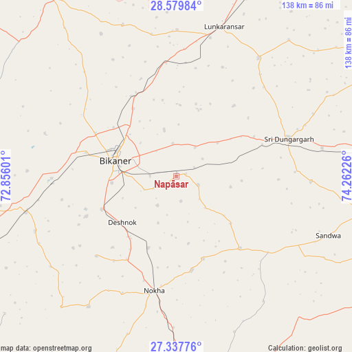
Napāsar GPS coordinates[2]
27° 57' 38.124" North, 73° 33' 32.868" East
| Map corner | latitude | longitude |
|---|---|---|
| Upper-left | 28.57984°, | 72.85601° |
| Center: | 27.96059°, | 73.55913° |
| Lower-right: | 27.33776°, | 74.26226° |
| Map W x H: | 138.1×138.1 km | = 85.8×85.8mi |
| max Lat: | 34.9274° ⇑15.7% North |
| Napāsar: | 27.96059° |
| min Lat: | ⇓84.3% South 8.09008° |
| min Long | Napāsar | max Long |
| 68.82655° | 73.55913° | 96.81° |
| W 7.7%⇐ | ⇒92.3% E |
Elevation
Elevation of Napāsar is 248 m = 814 ft, and this is 47.6 m = 156 ft below average elevation for this country.
| Max E: |
3681 m = 12077 ft | 40.4% |
| Avg. | 295.6 m = 970 ft | |
| Napāsar | 248 m = 814 ft | |
Min E: |
1 m = 3 ft | 59.6% |
See also: India elevation on elevation.city.
Geographical zone
Napāsar is located in North temperate zone (between Tropic of Cancer and the Arctic Circle). Distance of this Northern Tropic circle is 503 km =312.5 mi to South.| Distance of | km | miles | from Napāsar |
|---|---|---|---|
| North Pole | 6898.1 | 4286.3 | to North |
| Arctic Circle | 4292.2 | 2667 | to North |
| Tropic Cancer | 503 | 312.5 | to South |
| Equator | 3108.9 | 1931.8 | to South |


Nearby cities:
15 places around Napāsar: (largest is in red/bold)
• Basni
88.1 km =54.7 mi,  174°
174°
• Bhādāsar
81.7 km =50.8 mi,  61°
61°
• Bīkaner
24.8 km =15.4 mi,  284°
284°
• Chhāpar
87.9 km =54.6 mi,  100°
100°
• Deshnoke
27.9 km =17.3 mi,  229°
229°
• Kuchera
115.6 km =71.8 mi,  159°
159°
• Lādnūn
89.5 km =55.6 mi,  112°
112°
• Mūndwa
103.1 km =64.1 mi, 165°
• Nokha
45.2 km =28.1 mi,  191°
191°
• Nāgaur
86.1 km =53.5 mi, 168°
• Ratangarh
104.9 km =65.2 mi,  82°
82°
• Rājaldesar
90.2 km =56 mi,  85°
85°
• Sardārshahr
105.8 km =65.7 mi, 59°
• Sri Dūngargarh
46.6 km =29 mi,  71°
71°
• Sūjāngarh
93.8 km =58.3 mi, 107°
Sources, notices
• [Note1] Compared only with cities in India existing in our database
• [Src1] Map data: © OpenStreetMap contributors (CC-BY-SA)
• [Src2] Other city data from geonames.org with taken over terms of usage.
• [Src3] Geographical zone / Annual Mean Temperature by Robert A. Rohde @ Wikipedia
