Deshnoke geodata
Deshnoke (Rajasthan) is a populated place; located in India in Asia/Kolkata (GMT+5.5) time zone. With population of 16,720 people, there are 2312 cities with bigger population in this country. Compared to other cities in India, 83.5% of cities are located further ↓South; 93.1% of cities are located further →East and 63.4% of cities have lower elevation than Deshnoke. Note1


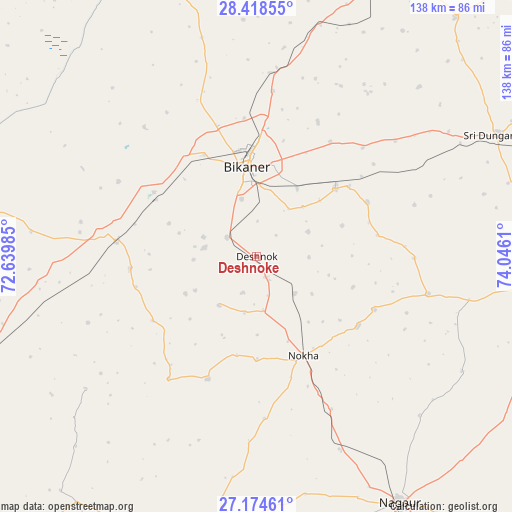
Deshnoke GPS coordinates[2]
27° 47' 54.096" North, 73° 20' 34.692" East
| Map corner | latitude | longitude |
|---|---|---|
| Upper-left | 28.41855°, | 72.63985° |
| Center: | 27.79836°, | 73.34297° |
| Lower-right: | 27.17461°, | 74.0461° |
| Map W x H: | 138.3×138.3 km | = 85.9×85.9mi |
| max Lat: | 34.9274° ⇑16.5% North |
| Deshnoke: | 27.79836° |
| min Lat: | ⇓83.5% South 8.09008° |
| min Long | Deshnoke | max Long |
| 68.82655° | 73.34297° | 96.81° |
| W 6.9%⇐ | ⇒93.1% E |
Elevation
Elevation of Deshnoke is 275 m = 902 ft, and this is 20.6 m = 68 ft below average elevation for this country.
| Max E: |
3681 m = 12077 ft | 36.6% |
| Avg. | 295.6 m = 970 ft | |
| Deshnoke | 275 m = 902 ft | |
Min E: |
1 m = 3 ft | 63.4% |
See also: India elevation on elevation.city.
Geographical zone
Deshnoke is located in North temperate zone (between Tropic of Cancer and the Arctic Circle). Distance of this Northern Tropic circle is 485 km =301.4 mi to South.| Distance of | km | miles | from Deshnoke |
|---|---|---|---|
| North Pole | 6916.2 | 4297.5 | to North |
| Arctic Circle | 4310.3 | 2678.3 | to North |
| Tropic Cancer | 485 | 301.4 | to South |
| Equator | 3090.9 | 1920.6 | to South |


Nearby cities:
15 places around Deshnoke: (largest is in red/bold)
• Basni
75.7 km =47 mi,  156°
156°
• Bhādāsar
109.2 km =67.9 mi,  58°
58°
• Bīkaner
24.5 km =15.2 mi,  353°
353°
• Chhāpar
107.9 km =67 mi,  88°
88°
• Kuchera
109.4 km =68 mi,  145°
145°
• Lādnūn
105.3 km =65.4 mi,  98°
98°
• Mūndwa
94.5 km =58.7 mi, 149°
• Napāsar
27.9 km =17.3 mi,  49°
49°
• Nokha
29.2 km =18.1 mi, 154°
• Nāgaur
76.7 km =47.7 mi, 149°
• Phalodi
121.5 km =75.5 mi,  232°
232°
• Ratangarh
129.2 km =80.3 mi,  75°
75°
• Rājaldesar
114.1 km =70.9 mi, 77°
• Sri Dūngargarh
73.3 km =45.5 mi, 63°
• Sūjāngarh
111.1 km =69 mi, 95°
Sources, notices
• [Note1] Compared only with cities in India existing in our database
• [Src1] Map data: © OpenStreetMap contributors (CC-BY-SA)
• [Src2] Other city data from geonames.org with taken over terms of usage.
• [Src3] Geographical zone / Annual Mean Temperature by Robert A. Rohde @ Wikipedia
