Nelamangala geodata
Nelamangala (Karnataka) is a populated place; located in India in Asia/Kolkata (GMT+5.5) time zone. With population of 28,697 people, there are 1504 cities with bigger population in this country. Compared to other cities in India, 85.8% of cities are located further ↑North; 58.4% of cities are located further →East and 95.2% of cities have lower elevation than Nelamangala. Note1


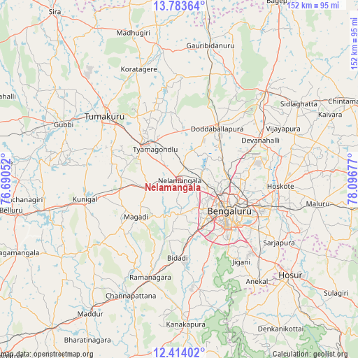
Nelamangala GPS coordinates[2]
13° 5' 59.208" North, 77° 23' 37.104" East
| Map corner | latitude | longitude |
|---|---|---|
| Upper-left | 13.78364°, | 76.69052° |
| Center: | 13.09978°, | 77.39364° |
| Lower-right: | 12.41402°, | 78.09677° |
| Map W x H: | 152.3×152.3 km | = 94.6×94.6mi |
| max Lat: | 34.9274° ⇑85.8% North |
| Nelamangala: | 13.09978° |
| min Lat: | ⇓14.2% South 8.09008° |
| min Long | Nelamangala | max Long |
| 68.82655° | 77.39364° | 96.81° |
| W 41.6%⇐ | ⇒58.4% E |
Elevation
Elevation of Nelamangala is 898 m = 2946 ft, and this is 602.4 m = 1976 ft above average elevation for this country.
| Max E: |
3681 m = 12077 ft | 4.8% |
| Nelamangala | 898 m 2946 ft | |
| Avg. | 295.6 m = 970 ft | |
Min E: |
1 m = 3 ft | 95.2% |
See also: India elevation on elevation.city.
Geographical zone
Nelamangala is located in North Torrid zone (between Equator and Tropic of Cancer). Distance of this Northern Tropic circle is 1149.4 km =714.2 mi to North.| Distance of | km | miles | from Nelamangala |
|---|---|---|---|
| North Pole | 8550.5 | 5313 | to North |
| Arctic Circle | 5944.6 | 3693.8 | to North |
| Tropic Cancer | 1149.4 | 714.2 | to North |
| Equator | 1456.6 | 905.1 | to South |


Nearby cities:
15 places around Nelamangala: (largest is in red/bold)
• Anekal
54.2 km =33.7 mi,  142°
142°
• Bengaluru
25.9 km =16.1 mi,  123°
123°
• Channapatna
53.8 km =33.4 mi,  202°
202°
• Chik Ballāpur
51.9 km =32.2 mi,  44°
44°
• Closepet
43.7 km =27.2 mi, 196°
• Dasarahalli
47.5 km =29.5 mi,  90°
90°
• Devanhalli
38.1 km =23.7 mi,  64°
64°
• Dod Ballāpur
26.7 km =16.6 mi, 35°
• Hoskote
43.9 km =27.3 mi, 94°
• Koratagere
49.9 km =31 mi,  340°
340°
• Kunigal
40.8 km =25.4 mi,  257°
257°
• Māgadi
24.3 km =15.1 mi,  229°
229°
• Tumkūr
41.4 km =25.7 mi,  310°
310°
• Vadigenhalli
49.3 km =30.6 mi, 63°
• Yelahanka
21.9 km =13.6 mi, 89°
Sources, notices
• [Note1] Compared only with cities in India existing in our database
• [Src1] Map data: © OpenStreetMap contributors (CC-BY-SA)
• [Src2] Other city data from geonames.org with taken over terms of usage.
• [Src3] Geographical zone / Annual Mean Temperature by Robert A. Rohde @ Wikipedia
